Wrangell-St. Elias National Park 2026 — America’s Largest Wilderness
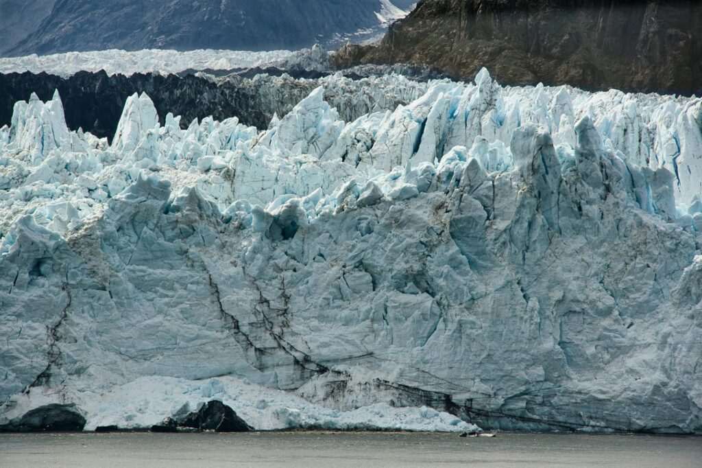
The numbers alone require a moment to absorb. Wrangell-St. Elias National Park encompasses 13.2 million acres — larger than Switzerland, larger than Yellowstone, Yosemite, and the Great Smoky Mountains combined. It contains four mountain ranges converging in a single landscape, nine of the sixteen highest peaks in the United States, and the largest non-polar glacial system on earth. The Bagley Icefield alone stretches 127 miles. Mount Wrangell, one of the park’s volcanic peaks, is an active stratovolcano. This is wilderness on a scale that resists easy comprehension, and it sits three to six hours from Anchorage depending on your mode of travel.
Wrangell-St. Elias receives fewer than 80,000 visitors per year — a fraction of Yellowstone’s four million — which means that traveling here is a fundamentally different experience from any other national park in the country. There are no crowds, no traffic jams at scenic pullouts, no reservation lotteries for campgrounds. What there is instead is an almost total absence of the infrastructure that filters the wilderness from the visitor. Coming here requires planning, flexibility, and acceptance of uncertainty — the rewards are proportional.
McCarthy and Kennicott: The Gateway Towns
The park’s only real visitor gateway is McCarthy, a small community at the end of a 60-mile dirt road off the Richardson Highway. McCarthy Road is unpaved, potholed, and crosses the Kennicott River via a footbridge — vehicles park at the road’s end and passengers walk across, then board a shuttle into town. The road limits access to vehicles that can handle rough conditions and drivers who are comfortable with remote travel. This is by design: McCarthy exists in something close to its historical state precisely because it is hard to reach.
Five miles above McCarthy sits Kennicott, a National Historic Landmark and one of the most remarkable industrial ruins in North America. The Kennicott Mines operated from 1903 to 1938, extracting copper from some of the richest ore deposits ever discovered. At peak production, the mines employed 300 workers year-round in conditions of extreme isolation. The remaining mill buildings — fourteen stories of rust-red timber rising above the glacier — have been partially restored and are operated as a historic site. The Kennicott Glacier stretches directly behind the buildings. Guided tours of the mill complex run in summer through the National Park Service and provide access to the historic interiors; self-guided walking of the town’s exterior is free.
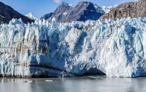
Root Glacier: Walk Onto the Ice
The Root Glacier is the most accessible of the park’s glaciers and the destination that turns a Kennicott visit from historical sightseeing into something more physically memorable. A flat, well-marked trail from Kennicott leads three miles to the glacier’s edge, crossing tundra and moraine before arriving at a river of blue-white ice that extends deep into the mountains. Ice crampon rentals are available in Kennicott from outfitters who also offer guided glacier walks. Walking on an actively moving glacier — seeing the crevasses, the meltwater streams, the deep blue of ancient compressed ice — is a transformative experience that requires no technical climbing skill and very little physical fitness beyond the ability to walk three miles on uneven terrain.
The Root Glacier trail also provides views of the Kennicott Mill buildings from above, and on clear days, sightlines deep into the Wrangell Mountains. This combination — historic industrial landmark, accessible glacier, and dramatic mountain scenery — makes Kennicott one of the most rewarding single destinations in Alaska for visitors who invest the time to reach it.
Flightseeing the Bagley Icefield
The Wrangell-St. Elias landscape is too large and too vertical to fully appreciate from the ground. Flightseeing from McCarthy or the nearby Chitina airstrip puts the scale in immediate, visceral perspective. Several operators based in McCarthy offer flights over the Bagley Icefield — a glacial system so vast that it covers more than 2,300 square miles — and over the park’s volcanic peaks, including the summit craters of Mount Wrangell. Glacier landings are possible on several routes, offering a brief but profound encounter with an ice surface that has been accumulating for thousands of years. Flight durations range from 45 minutes to two hours depending on the route; prices run $200–$400 per person. Book well in advance — McCarthy’s aviation operators have limited seats and summer demand is high relative to capacity.
Nabesna Road: The Northern Wilderness
The park’s second road access, Nabesna Road, enters from the north off the Tok Cutoff Highway and extends 42 miles into the park’s interior before ending at the private community of Nabesna. The road is rougher than McCarthy Road — a high-clearance vehicle is strongly recommended, and the final miles require four-wheel drive — and far less visited. What it offers in return is near-total solitude, excellent moose and bear habitat, and a sense of true wilderness immersion that even McCarthy, with its small visitor community, cannot fully provide. Several backcountry campsites line the road, and the surrounding landscape opens up to views of the Wrangell Mountains that are unavailable from anywhere else. This is the correct choice for experienced wilderness travelers who want to be genuinely alone with the park.
Wilderness Rafting
The Kennicott and Nizina Rivers offer multi-day wilderness float trips that rank among the most remote rafting experiences in Alaska. The Nizina canyon in particular — a narrow gorge cut through the Wrangell foothills — is accessible only by raft and is known for its technical whitewater, canyon walls, and near-guaranteed wildlife encounters. These are not commercial day trips but serious wilderness expeditions requiring either strong self-sufficiency or a licensed guide. Several McCarthy-based outfitters offer guided multi-day Nizina floats; they provide the rafts, permits, and logistics that make the trip accessible to visitors without prior Alaska wilderness rafting experience.
Wildlife
Wrangell-St. Elias supports populations of Dall sheep on the mountain ridges, caribou in the valley bottoms, grizzly bears throughout the park, wolves, wolverines, and moose. The park’s size and low visitor pressure mean wildlife encounters happen on the animals’ terms rather than at designated viewing pullouts. Dall sheep are consistently visible from the Kennicott area on the surrounding ridgelines. Bears are present wherever you go in the park; bear canisters are required for backcountry camping.
Getting There and When to Visit
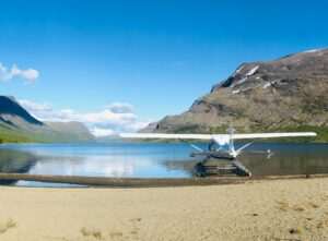
From Anchorage, McCarthy is reached by driving the Glenn Highway east to Glennallen, then south on the Richardson Highway, then east on the Edgerton Highway to Chitina, then northeast on McCarthy Road — approximately six to seven hours total. An alternative is flying: small charter flights from Anchorage to the McCarthy airstrip take about an hour and can be arranged through McCarthy-based aviation operators or Anchorage charter services. The flight option is worth considering if you have limited time, as the drive is long and McCarthy Road requires full daylight and good conditions.
Full access runs June through early September. The park is theoretically open year-round, but McCarthy Road becomes impassable after the first significant autumn snowfall, and winter access requires snowmachines or ski planes. July offers the best combination of long daylight, passable roads, and maximum wildlife activity. Early June and September bring smaller crowds and often spectacular weather, but some services in McCarthy are reduced at the season’s edges. If you are planning a glacier hike or flightseeing trip, factor in that poor weather can close operations for multiple consecutive days — building at least two nights in McCarthy into your itinerary provides the flexibility to wait out a weather window.
Wrangell-St. Elias rewards visitors who make the effort to reach it with something increasingly rare: wilderness that still operates on its own terms, at its own scale, without accommodation for the human preference for convenience. Getting there is part of the experience.
Featured photo by Stephen Meyers on Pexels.

No comments yet.