Ketchikan Alaska 2026: Totem Poles, Misty Fjords & the Rainiest Town in America
Ketchikan receives more than 160 inches of rain per year. It says this on the welcome signs. The locals have leaned into it so completely that the city’s rain jacket culture, the moss-covered boardwalks, and the deep saturated green of the surrounding temperate rainforest have become sources of civic pride rather than apology. Ketchikan is the southernmost city in Alaska, accessible from Anchorage by a 1.5-hour Alaska Airlines flight, and it offers a version of Alaska entirely different from the Southcentral experience: Indigenous cultural depth, exceptional sportfishing, some of the most dramatic fjord scenery in North America, and a historic downtown built on pilings over a salmon-running creek. Pack waterproof everything and arrive without expectations of sunshine. What you find instead is better.
Getting There from Anchorage
Alaska Airlines operates direct flights between Ted Stevens Anchorage International Airport and Ketchikan International Airport, with flight time approximately 1.5 hours. The airport is on Gravina Island, separated from downtown by the Tongass Narrows; a short ferry connects the airport to the city (the same narrow crossing that briefly became national news as the proposed site of the “Bridge to Nowhere”). There is no road connection between Ketchikan and the rest of Alaska’s highway system — the city is accessible only by air or the Alaska Marine Highway ferry. A 2-to-3-night stay is the minimum for doing justice to the main attractions; a day trip from Anchorage is technically possible but rushed.
Totem Bight State Historical Park
Ten miles north of downtown on the North Tongass Highway, Totem Bight State Historical Park holds one of the finest collections of standing totem poles in Southeast Alaska — 14 restored poles and a reconstructed clan house set on a forested point above the Tongass Narrows. The poles were rescued and restored in the 1930s and 1940s as part of a federal program to salvage deteriorating poles from abandoned Tlingit and Haida village sites before they were lost entirely. The restoration brought master carvers and their apprentices to Ketchikan to recreate works that would otherwise have rotted back into the forest.
The setting amplifies the experience: the poles stand in a coastal spruce and hemlock forest, with the sound of the narrows audible through the trees and the light filtering through the canopy onto carved cedar. Entry is free. Allow at least an hour and bring waterproof gear; the trail through the park is unpaved and wet.
Saxman Native Village
Two miles south of downtown, Saxman is a Tlingit village with what is considered the world’s largest collection of standing totem poles — approximately 24 poles displayed in a park setting adjacent to the village. What distinguishes Saxman from a museum exhibit is that the work continues: the carving shed adjacent to the park is a working facility where master carvers and apprentices carve poles, paddles, and regalia using traditional techniques. Visitors can watch the work in progress and speak with carvers about the process and meaning of the poles.
Guided tours of Saxman include cultural performances and explanations of specific poles’ narratives — each pole tells a story or commemorates an event or family lineage, and without that context the visual complexity can be opaque. The tours are run by Cape Fox Tours and are worth booking in advance for summer visits. Even without the guided tour, the pole park is open to walk-in visitors and the carving shed is visible from the public path.
Creek Street
Creek Street is the historic boardwalk district at the heart of downtown Ketchikan, built on pilings over Ketchikan Creek. During the fishing and gold rush era, it operated as the town’s red-light district — the standard description is that it was the place “where both the fish and the fishermen come to spawn,” which remains accurate in the second half. The boardwalk is now a district of galleries, boutiques, and restaurants, but the history is present in Dolly’s House, a preserved and now-operating museum in the former bordello of Dolly Arthur, who worked Creek Street for decades.
During the salmon runs — typically July through September — pink and coho salmon are visible in the creek directly below the boardwalk, often in dense schools surging upstream against the current. Watching salmon from the boardwalk with a halibut fish and chips from one of the nearby restaurants is a quintessentially Ketchikan afternoon. The Creek Street Connector funicular runs up the hillside to a hotel at the top; the lower boardwalk is the more interesting stretch.
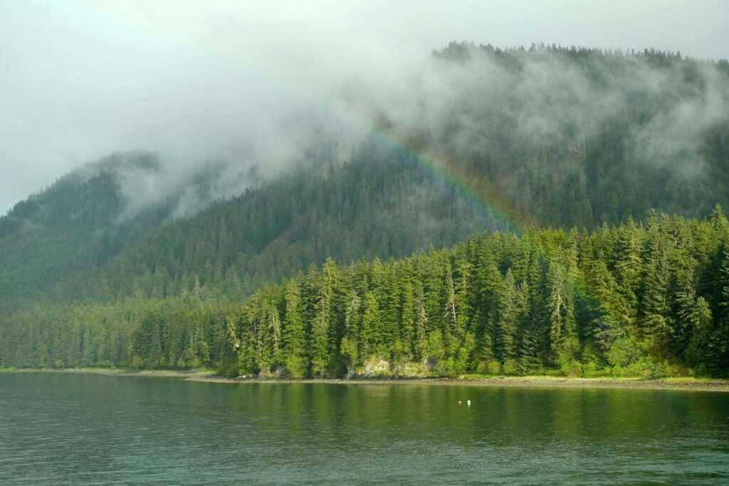
Misty Fjords National Monument
Misty Fjords National Monument is 2.3 million acres of roadless wilderness beginning 22 miles east of Ketchikan — a landscape of vertical granite cliffs rising 3,000 feet from the water’s surface, narrow fjords lined with old-growth Sitka spruce, and waterfalls dropping from the rock faces directly into salt water. It is one of the most dramatic landscapes in Alaska, which is saying something, and it is accessible only by boat or floatplane.
Two approaches:
- Boat tour: A 4-to-6-hour tour from Ketchikan’s downtown dock through the Tongass Narrows and into Rudyerd Bay, the most dramatic section of the monument, where the granite walls close in on either side of the fjord. Tours typically include time anchored at the face of the cliffs and occasional wildlife sightings — black bears on the shoreline, bald eagles in the trees, harbor seals on rocks. Multiple operators run daily tours in summer; book 1-2 weeks ahead for July and August.
- Floatplane flightseeing: A 1.5-to-2-hour flight over and through the monument, typically landing on a lake in the interior for a short walk before returning. The aerial perspective — looking down into the fjords, seeing the full scale of the granite formations, the waterfalls threading down to the water — gives a different understanding of the monument’s geography. Some operators run combination tours: boat out, floatplane back.
Salmon Fishing
Ketchikan calls itself the Salmon Capital of the World, and the claim is not marketing hyperbole. The waters around the city produce five species of Pacific salmon across a season that runs from May through October, with king (Chinook) salmon running in May through July, sockeye and pink salmon through summer, and silvers (coho) extending into October. Charter operators depart from downtown and the Thomas Basin marina; a full-day guided trip for two or four anglers typically runs $250–$350 per person. The halibut grounds in nearby waters are equally productive; combination salmon-halibut charters are a standard format. Book 2-3 weeks ahead for prime season dates.
Southeast Alaska Discovery Center
The Southeast Alaska Discovery Center at 50 Main Street downtown is a Forest Service and National Park Service interpretive center covering the natural and cultural history of Southeast Alaska’s Tongass National Forest — the largest national forest in the United States. Exhibits cover the temperate rainforest ecosystem, Alaska Native cultures of the region, commercial and subsistence fishing, and the ongoing conservation and timber debates that have shaped Southeast Alaska politics for decades. Admission is approximately $5; the building is a good first-stop orientation before heading to the parks and village sites, particularly for visitors unfamiliar with the complexity of Tlingit and Haida cultural geography.
The Rain: A Practical Note
Ketchikan receives 160+ inches of rain in a typical year, making it one of the wettest cities in the United States. The rain is what makes the temperate rainforest: the Sitka spruce, the ferns covering every surface, the moss on the rooftops, the waterfalls visible from the boardwalk. Bring a high-quality waterproof jacket (not water-resistant — waterproof), waterproof boots, and the expectation that you will be wet at some point. Pack a dry bag for camera gear if you are shooting outdoors. Everything you want to see is outside. There is no version of a Ketchikan visit that is primarily indoors. The rain is the price of the green, and the green is extraordinary.
Ketchikan is where Alaska’s Indigenous cultures are most immediately present to a visitor — in the standing poles, the working carvers, the fish in the creek below the boardwalk. The rain keeps the crowds manageable on days when cruise ships are not in port, and the misty quality of the light on the narrows is exactly what the monument to the east is named for. Go in the rain. Go for the poles. Stay for the fish.

No comments yet.