Reed Lakes Trail Hatcher Pass: Best Alpine Hike 2026
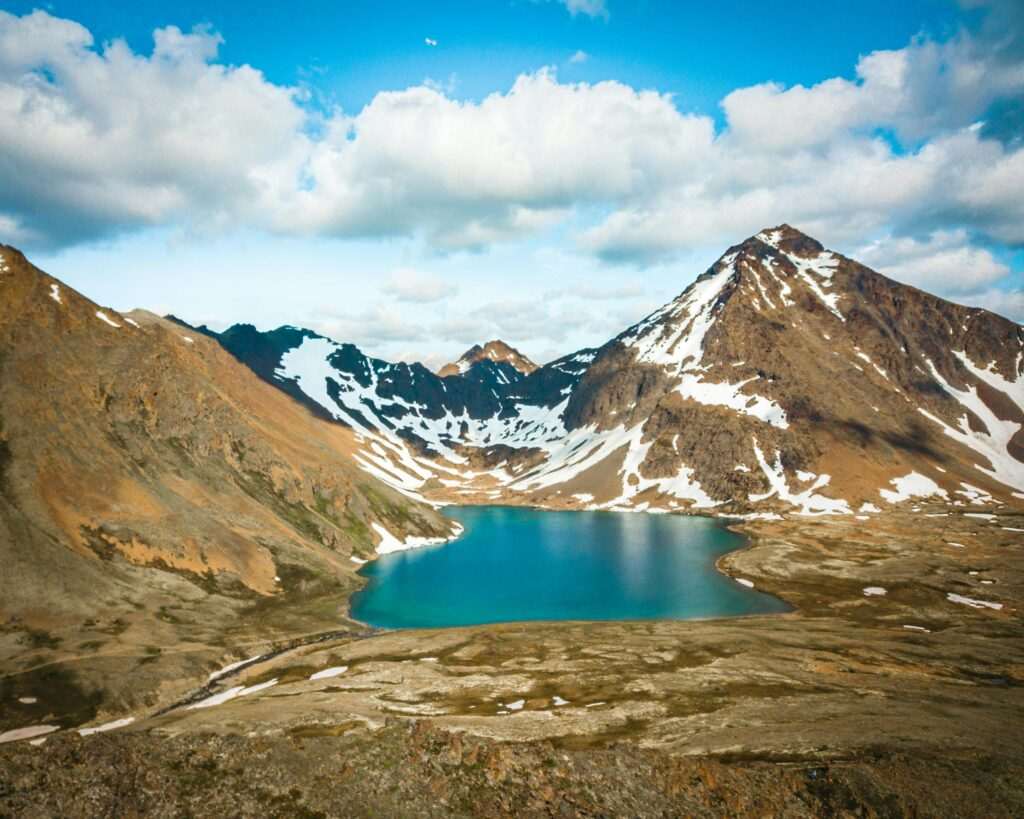
Seventy-five miles north of Anchorage in the Talkeetna Mountains, the Archangel Valley holds two of the most striking alpine lakes in Southcentral Alaska. Lower Reed Lake and Upper Reed Lake sit in a glacier-carved cirque above treeline, their aqua-blue water reflecting the rocky ridgelines and snowfields that surround them on three sides. The Reed Lakes Trail is 10 miles round trip to the upper lake, with 1,800 feet of elevation gain — a genuine full-day hike that earns its destination in every sense. It’s one of the best day hikes accessible from Anchorage, and it’s consistently underrated outside of local hiking circles.
The Trail
The Reed Lakes Trail begins at the end of Archangel Valley Road, a gravel spur off Hatcher Pass Road. The first two miles follow a well-defined path alongside Archangel Creek through willow thickets and subalpine meadows, gaining elevation steadily. The terrain is open and navigation isn’t a concern. Late July brings dense wildflower patches — lupine, fireweed, and arctic paintbrush — through the lower meadows.
Lower Reed Lake appears at roughly mile 4. The lake is vivid aqua-blue, fed by snowmelt from the surrounding ridges, and it sits in a bowl that frames the upper cirque above. Most visitors who turn back at Lower Reed Lake leave satisfied — the views from the lake are already substantial. But Upper Reed Lake, two miles further, is in a different class of scenery. The terrain above Lower Reed Lake becomes rockier and the trail less defined; some basic route-finding across talus and moraine is required. The upper lake sits in a tighter, more dramatic cirque, with snowfields often persisting on the north-facing walls into August.
Difficulty
The Reed Lakes Trail is rated strenuous. The 10-mile round trip to Upper Reed Lake involves 1,800 feet of elevation gain, significant exposure above treeline, and route-finding on the upper section that requires attention. Budget 6 to 8 hours for the full round trip, including time at both lakes. Hikers who are comfortable on moderate terrain and in reasonable physical condition can complete it, but it isn’t a casual outing. Trekking poles earn their weight on the descent from the upper cirque.
Wildlife
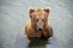
Dall sheep are a consistent presence on the ridgelines above the cirque — binoculars will usually locate groups of them on the upper faces. Ptarmigan are common in the talus fields; their summer plumage blends well and they can be surprisingly hard to spot. Marmots are abundant above the lower lake, their whistles audible from the trail. The area has black and brown bear activity — carry bear spray and make noise through the willows on the lower trail.
Getting There
The Archangel Valley trailhead is approximately 75 miles from downtown Anchorage, about a 1.5-hour drive. The most common route follows the Glenn Highway northeast from Anchorage to Palmer, then Fishhook-Willow Road (Fishhook Road) northwest toward Hatcher Pass. The road climbs steeply into the mountains and eventually reaches the Hatcher Pass area; stay on Hatcher Pass Road past the Independence Mine turnoff and follow signs for Archangel Valley Road, a gravel spur that leads to the trailhead parking.
Cell service is unreliable in the Archangel Valley — download offline maps before leaving Anchorage. The road to the trailhead is passable for standard passenger vehicles but the gravel surface rewards slower speeds. Arrive by 8 AM on summer weekends; the lot fills early.
Season and Conditions
The Reed Lakes Trail is typically snow-free from early July through late September. Snow can linger in the upper cirque and on the trail to Upper Reed Lake well into July in heavy-snow years; check current conditions before committing to the upper lake. Late July is the wildflower peak on the lower trail. September brings blueberry season on the tundra slopes and cooler temperatures that make the climb more comfortable, though afternoon weather in the mountains can shift quickly — pack rain gear regardless of the morning forecast.
Combining with Hatcher Pass
The Independence Mine State Historical Park is a few miles back down Hatcher Pass Road — a gold mine complex from the 1930s–1940s open for self-guided tours, with well-preserved buildings and solid interpretive displays. It’s a natural add-on after Reed Lakes, especially for visitors who want context on the mining history that shaped this valley.
Heading back toward Anchorage, the Musk Ox Farm in Palmer is worth a stop — the only farm in the world dedicated to domesticating musk oxen, with close-up viewing of the animals and exhibits on qiviut, the extraordinarily warm fiber combed from their coats each spring. It’s a 20-minute detour on the way home and unlike anything else in the state.
How long is Reed Lakes Trail?
The full round trip to Upper Reed Lake is approximately 10 miles with about 1,800 feet of elevation gain. Most hikers budget 6 to 8 hours. Lower Reed Lake is reached at roughly mile 4 — an 8-mile round trip that cuts the technical difficulty and time significantly.
How do you get to Reed Lakes Trail from Anchorage?
Take the Parks Highway north from Anchorage to Palmer, then follow Fishhook Road northwest through the mountains to Hatcher Pass Road. Continue past the Independence Mine area and take Archangel Valley Road to the trailhead. The drive is approximately 75 miles and takes about 1.5 hours. Cell service is unreliable — download offline maps before leaving.
When is the best time to hike Reed Lakes Trail?
Mid-July through September is the prime window. Snow typically clears from the lower trail by early July; the upper cirque may hold snow later. Late July offers peak wildflowers. September brings fall color and cooler temperatures. Check conditions before visiting as upper-elevation snowpack varies significantly year to year.
Is Reed Lakes Trail suitable for beginners?
The lower section to Lower Reed Lake (8 miles RT) is manageable for fit hikers with some trail experience. The upper section to Upper Reed Lake adds technical terrain and route-finding that isn’t recommended for beginners. In both cases, the elevation gain and exposed alpine terrain make this a meaningful physical commitment — it isn’t a casual nature walk.
Reed Lakes rewards the drive. Two vivid alpine lakes, a glacier-carved cirque, Dall sheep on the ridges above — it’s the kind of hike that stays with people. Add Independence Mine on the way out and the Musk Ox Farm in Palmer on the drive home. Leave Anchorage early, carry layers and bear spray, and arrive before the trailhead lot fills.
Featured photo by Andrew Hanson on Pexels.

No comments yet.