Primrose Trail 2026: Kenai Peninsula’s Hidden Gem Hike Near Seward
Most Anchorage visitors who drive the Seward Highway spend their energy at Exit Glacier or on a Kenai Fjords boat tour. The Primrose Trail sits a few miles past Moose Pass with almost no signage and a gravel campground turnoff that blends into the treeline — easy to miss, easy to skip, and consequently one of the best hikes on the entire peninsula without the crowds. This guide covers everything you need to plan a day trip from Anchorage to one of the Kenai Peninsula’s most rewarding trails.
Where Is the Primrose Trail?
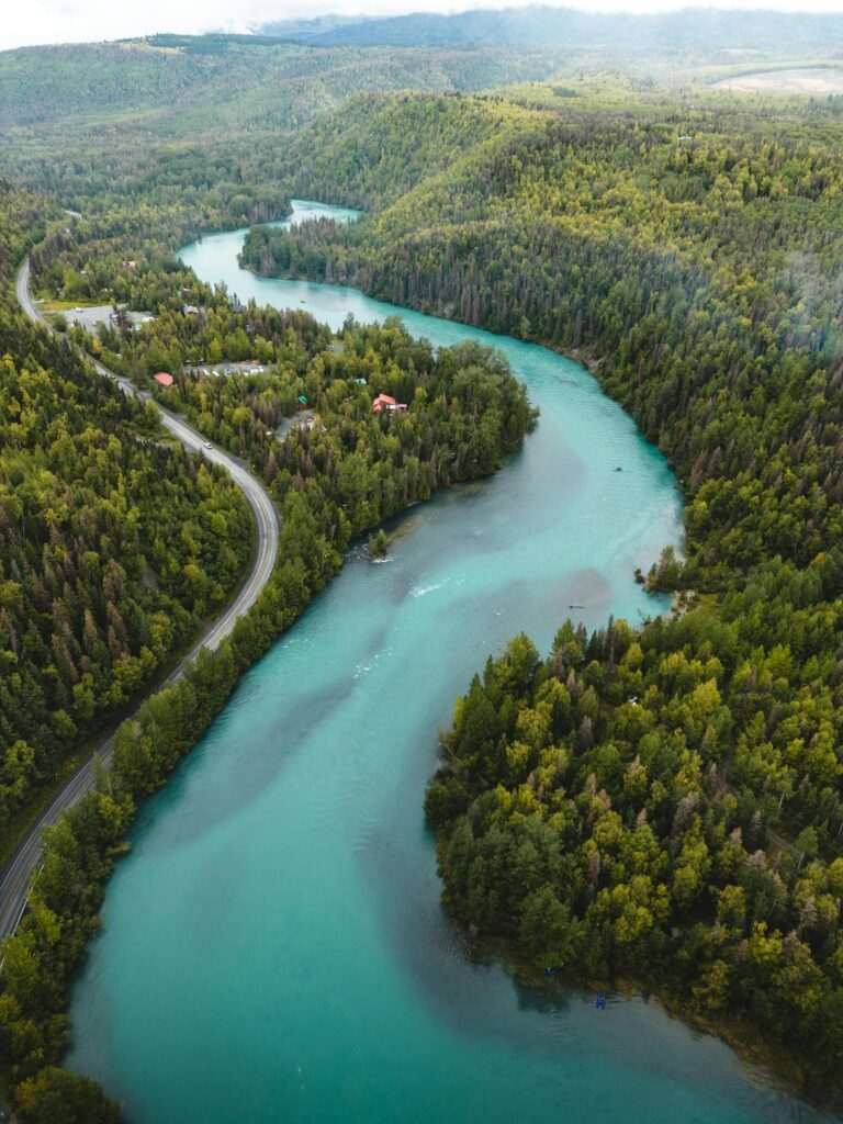
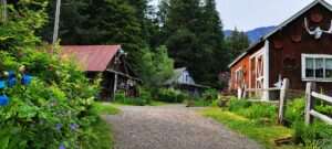
The Primrose Trail starts at Primrose Campground on the eastern shore of Kenai Lake, roughly 100 miles south of Anchorage near the town of Moose Pass. From Anchorage, take the Seward Highway south and watch for the Primrose Campground sign at approximately Mile 17 of the Seward Highway (the highway mileposts count down toward Seward from the north). The gravel access road leads about half a mile to the campground and trailhead. Total drive time from downtown Anchorage is about two and a half hours, including a gas stop — plan accordingly.
Parking at the trailhead is managed by the U.S. Forest Service and a fee may apply (typically $5 for day use). The Primrose Campground itself has nine campsites available for overnight stays at around $18 per night, making it a viable base for a multi-day Kenai Peninsula trip rather than just a day hike.
Trail Overview and Stats
The Primrose Trail climbs from the shore of Kenai Lake at roughly 450 feet elevation to the alpine terrain above treeline, covering approximately 8 miles round-trip to the Lost Lake junction. One-way distance to Lost Lake is about 5 miles with roughly 1,800 feet of elevation gain. The trail is rated moderate to strenuous — the lower sections through forest are relatively gradual, but the final push to the alpine zone involves sustained climbing on a rocky path.
The trail is well-maintained by the Forest Service and marked clearly at major junctions. It is not a loop on its own: the out-and-back to Lost Lake is the standard day hike option. A longer loop is possible by connecting to the Lost Lake Trail and descending into the town of Seward, but that route covers approximately 19 to 20 miles total and is a serious undertaking requiring a vehicle shuttle or pre-arranged pickup in Seward.
What You’ll See: Three Distinct Zones
The Forest Section (Lower Trail)
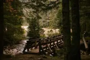
The first two miles climb steadily through dense Sitka spruce and hemlock forest typical of the Kenai Peninsula’s wetter eastern slopes. The canopy closes overhead, the air smells of moss and wet bark, and the trail runs alongside a stream that provides reliable water (treat before drinking). This section can be muddy in early season — waterproof footwear earns its keep here.
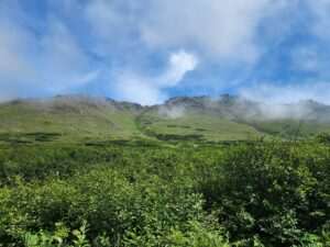
Subalpine Meadows (Mid-Trail)
Around mile two, the forest thins and the trail enters open subalpine meadows that are among the most flower-dense environments on the Kenai Peninsula in midsummer. Fireweed, lupine, paintbrush, and cow parsnip bloom in overlapping waves from late June through August, turning the hillsides vivid purple, pink, and white. The views open dramatically here — Kenai Lake stretches out below, framed by steep forested ridges, and on clear days the surrounding peaks reflect in the water thousands of feet below.
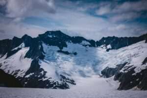
Alpine Tundra (Upper Trail)
Above treeline, the landscape transitions to open tundra with low-growing heath plants, occasional lingering snowfields in early summer, and the rocky terrain typical of Kenai Peninsula alpine zones. Lost Lake appears in a broad cirque — a clear, cold alpine lake ringed by peaks and scree slopes. The scale of the surrounding terrain is striking after the enclosed forest lower down. This is where most day hikers choose to stop, eat lunch, and turn around.
Wildlife on the Primrose Trail
The trail passes through excellent moose habitat in the lower forest section, and encounters are common in early morning and evening. Black bears frequent the berry patches along the mid-trail meadows from late July through September. Higher up, Dall sheep are occasionally visible on the rocky ridges flanking the Lost Lake cirque, and marmots are common across the alpine tundra. Songbirds and raptors are active throughout the trail, and the lake itself often hosts nesting birds.
Carry bear spray and make noise on the approach through dense vegetation. The trail’s relative quiet makes it bear country in the literal sense — you are more likely to encounter wildlife here than on more heavily trafficked Kenai trails. If your wildlife curiosity extends to organized programming, the Eagle River Nature Center north of Anchorage offers guided wildlife interpretation that can provide useful context before you head into the field.
Best Season and Conditions
The Primrose Trail is hikeable from approximately mid-June through late September in most years. Snow lingers on the upper sections well into June — the meadows may be clear while Lost Lake sits under two feet of snow. Checking current conditions with the Seward Ranger District (USFS) before your trip is worthwhile in early season. July and August offer the most reliable conditions and peak wildflower display. September brings blueberries and crowberries at mid and upper elevations, fall foliage in the birch patches, and significantly fewer hikers.
Mosquitoes are heavy in the lower forest section through mid-July. Insect repellent and a head net make the lower trail considerably more pleasant. Above treeline, wind typically keeps insects at bay.
Practical Tips
Water: The stream in the lower forest section provides abundant water; bring a filter or purification tablets. Above treeline, Lost Lake is a reliable source. Don’t count on water in the meadow section in dry late-summer conditions.
Bear canisters: Not required for day hikes but recommended for any overnight use. If camping at the USFS campground, hang food properly — this is active bear country year-round.
Footwear: Waterproof trail runners or light hiking boots are appropriate. The lower forest section stays wet throughout summer. The upper rocky terrain is rough enough that ankle support helps on the descent.
Cell service: Unreliable along the Seward Highway past Turnagain Pass and essentially absent at the trailhead. Download offline maps before leaving Anchorage.
Combining with Other Stops on the Seward Highway
The Seward Highway between Anchorage and the Kenai Peninsula is one of the most scenic drives in North America, and several stops pair naturally with a Primrose Trail day trip. Portage Valley is about 50 miles south of Anchorage — Portage Glacier Cruises run daily in summer and add a glacier boat tour to an already full day without major detour. Further south, Turnagain Pass has roadside hiking and a reliable stopping point for photographs of the Kenai Mountains reflected in the inlet.
Anchorage-based hikers looking to compare difficulty and scenery across multiple day hike options will find useful context at the Chugach State Park trail systems page — the Chugach trails directly east of the city offer similar alpine terrain at shorter drive times, making them a useful benchmark when deciding whether the longer Kenai Peninsula commitment suits your schedule.
Is the Primrose Trail Worth It?
The two-and-a-half-hour drive from Anchorage is the only real barrier to the Primrose Trail, and it is a scenic drive in its own right. Once at the trailhead, the trail rewards with genuine alpine character, flower meadows that rival any display in southcentral Alaska, and the kind of quiet that the more accessible Kenai trails no longer offer on summer weekends. For visitors with a full day to spend and a vehicle, it belongs near the top of the Kenai Peninsula day hike list.
No comments yet.