Dalton Highway & Arctic Circle Road Trip 2026: Driving Alaska’s Most Remote Road
The Dalton Highway doesn’t have a gentle on-ramp into the experience. Within the first hour north of Fairbanks, the pavement ends, the truck traffic begins, and the road makes clear that this is not a recreational drive in any conventional sense. The 414-mile gravel highway from Fairbanks to Deadhorse on the Arctic Ocean was built in 1974 to service the Trans-Alaska Pipeline — it is an industrial haul road that happens to be legally open to the public, not a scenic byway engineered for tourists. That distinction is the point. For visitors willing to prepare properly and accept significant logistical demands, driving the Dalton is among the most singular overland experiences available anywhere in North America: crossing the Arctic Circle, punching through the Brooks Range at Atigun Pass, and arriving at the edge of the Arctic Ocean at the most remote publicly accessible point on the continent.
The Road: What You’re Actually Driving
The Dalton Highway (Alaska Route 11) begins at a junction 84 miles north of Fairbanks and runs 414 miles to Deadhorse, the industrial staging area adjacent to Prudhoe Bay. Most of the road surface is gravel or dirt, with short paved sections near communities and at key crossings. The highway is active year-round as a commercial haul route for the oil fields — semi-trucks running 24 hours a day are the dominant users, and their wake creates road conditions that are hard on vehicles and windshields. Flying gravel from passing trucks has destroyed windshields on vehicles without protective screens.
There are effectively three service points on the entire route: the Yukon River crossing at mile 56 (fuel, food, limited supplies), Coldfoot Camp at mile 175 (the last full services for 240 miles northbound), and Deadhorse at the end of the road. Between Coldfoot and Deadhorse, there is nothing — no gas stations, no services, no cell coverage, no rescue infrastructure. That 240-mile stretch is what makes the Dalton a serious undertaking rather than a long drive.
Key Stops Along the Route
Arctic Circle Crossing — Mile 115. The official Arctic Circle marker sits at mile 115, where the highway crosses 66.5 degrees north latitude. A large timber sign marks the crossing, and it is one of the most photographed stops on the Dalton for obvious reasons. The Alaska Public Lands Information Center in Fairbanks issues free certificates for verified Arctic Circle crossings — pick up the form before you leave or request it by mail afterward. The crossing feels genuinely meaningful; north of here, the sun does not set on the summer solstice and does not rise on the winter solstice, and the landscape has already begun shifting toward the open boreal forest and tundra that define the Arctic.
Yukon River Camp — Mile 56. The Dalton crosses the Yukon River via a single-lane bridge — the only road bridge across the Yukon in Alaska — at mile 56. The Yukon River Camp here offers food, fuel, and limited lodging, and it is worth stopping to appreciate the scale of the river. The Yukon at this crossing is nearly half a mile wide, brown and powerful, carrying snowmelt from an enormous drainage that extends into Canada.
Coldfoot Camp — Mile 175. Coldfoot is a former gold rush settlement that now operates as the primary services hub for the upper Dalton. The camp offers fuel, meals, a small hotel, and an Arctic Interagency Visitor Center staffed by National Park Service and Bureau of Land Management rangers who can provide current road conditions, wildlife sightings, and safety information. Fill the tank completely at Coldfoot regardless of your fuel level — it is the last gas station for 240 miles. The visitor center is worth an hour: the exhibits on Arctic ecology, pipeline construction history, and Brooks Range geology are substantive and well-curated.
Wiseman — Mile 188. Two miles off the Dalton sits Wiseman, a tiny historic mining community of about a dozen year-round residents that has been continuously inhabited since the gold rush era. Unlike Coldfoot, Wiseman is not a service community — it is an actual place where people live, with historic buildings, sled dog lots, and a community that has maintained a genuinely remote Arctic existence for over a century. A short visit gives a human scale to the landscape that the vast tundra vistas don’t provide.
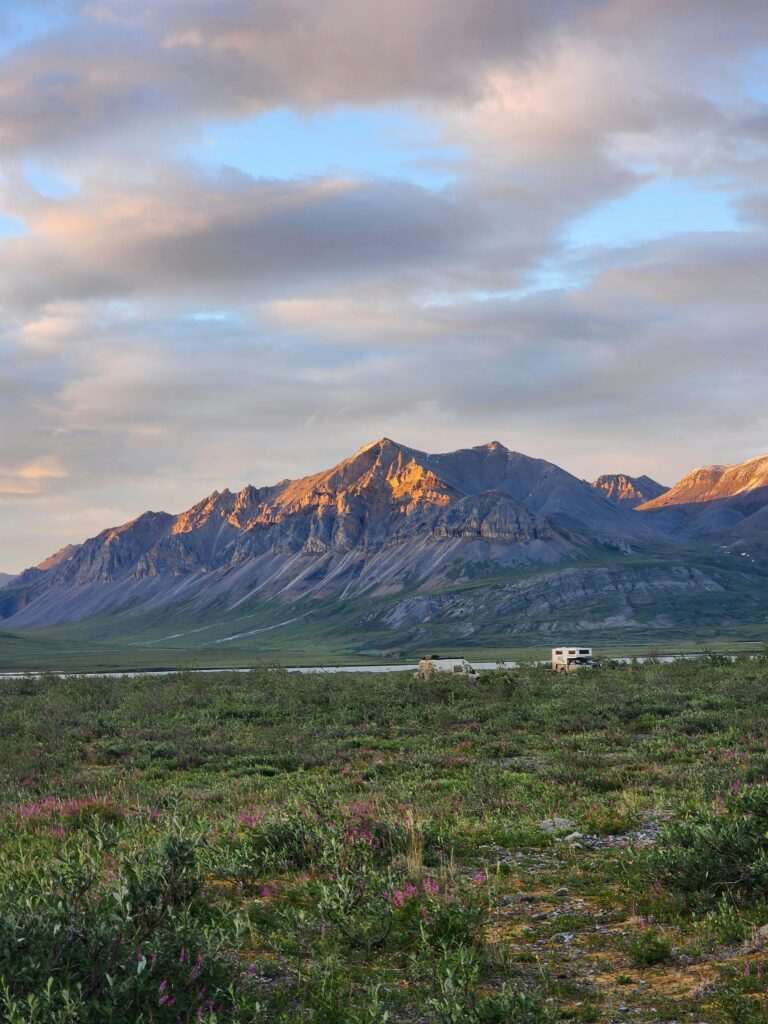
Atigun Pass — Mile 244. The highway crosses the Brooks Range at Atigun Pass, elevation 4,739 feet — the highest mountain pass on any Alaska highway. The approach is dramatic in both directions: north-facing tundra gives way to the jagged limestone peaks of the Brooks Range, and the descent on the south side reveals the open tundra of the North Slope stretching toward the Arctic Ocean. Dall sheep are regularly visible on the pass slopes. In early summer, snowfields linger on the high terrain well into June. This is the emotional and geographical center of the Dalton experience — the moment where the drive crosses from boreal forest into true Arctic terrain.
Deadhorse and Prudhoe Bay. The road ends at Deadhorse, an oil-field staging and processing facility that is the definition of functional rather than scenic. Access to the actual Arctic Ocean shoreline requires a tour — the oil-field infrastructure around Prudhoe Bay is on private industrial land, and visitors cannot drive to the water independently. Daily tours from the Prudhoe Bay Hotel grant access to the beach, where you can touch the Arctic Ocean. For most Dalton drivers, touching the water is the culminating act of the trip — standing at the edge of an ocean that most people never see, having driven a road that most people never drive.
Wildlife on the Dalton
The Dalton corridor passes through some of the most productive wildlife terrain in North America. The Central Arctic Caribou Herd — numbering approximately 70,000 animals — uses the North Slope for summer calving and migration. Seeing the herd cross the highway is possible and memorable; in peak migration windows in June and September, groups of hundreds or thousands of animals can block the road for extended periods. Grizzly bears are present throughout the corridor and frequently visible from the road, particularly in berry-productive areas in late summer. Dall sheep appear consistently at Atigun Pass and on the limestone ridgelines of the Brooks Range. Musk ox, reintroduced to Alaska in the 1930s after being hunted to extirpation, are regularly seen near Deadhorse and on the North Slope tundra — primordial-looking animals that have survived since the Pleistocene and show no concern for passing vehicles.
Vehicle Requirements and Safety Preparation
Self-driving the Dalton requires specific vehicle preparation. High ground clearance is essential — the road surface is irregular, and low-clearance vehicles will sustain undercarriage damage. Carry two full-size spare tires: tire punctures from gravel are common, and a single spare is inadequate for a 240-mile serviceless stretch. Carry extra fuel beyond your expected range — at minimum, enough for 300 miles from Coldfoot to Deadhorse and back, since Deadhorse fuel is available but expensive and not always accessible immediately on arrival. A satellite communicator (SPOT, Garmin InReach) is essential for emergency communication in the zero-cell-coverage zones between the Yukon River and Deadhorse.
Windshield protection is worth serious consideration. Semi-truck traffic on the Dalton throws substantial gravel, and many self-drive visitors arrive in Deadhorse with cracked or shattered windshields. Temporary plastic windshield protectors are available at Fairbanks auto parts stores, and Big Ray’s Outdoor Gear in Anchorage carries additional vehicle preparation items for remote road travel. The investment in preparation is trivial compared to the cost of a windshield replacement 400 miles from the nearest glass shop.
Guided Tours: The Alternative to Self-Driving
For visitors who want the Arctic Circle experience without the vehicle logistics, guided overland tours operate from Fairbanks to the Arctic Circle and in some cases all the way to Deadhorse. Adventures by True North and other Fairbanks-based operators run multi-day guided tours that provide purpose-built vehicles, knowledgeable guides, and logistical support that eliminates the safety calculus of independent travel. The guided format also adds interpretive depth — the ecological, geological, and pipeline history of the corridor is considerably richer with a guide than without one.
An alternative for visitors short on time: fly directly to Deadhorse (daily flights from Fairbanks via Get Up And Go Tours or Alaska Airlines codeshare) and take the Prudhoe Bay tour to touch the Arctic Ocean — the endpoint experience without the 800-mile drive.
Best Time to Drive
June through August is the primary self-drive window. Midnight sun driving — navigating the Dalton at 11 PM in full daylight — is a surreal and productive way to cover ground without the day’s truck traffic peak. September brings fall color across the tundra (dwarf birch and cottongrass turning gold and red), peak caribou migration activity, and dramatically reduced visitor numbers, at the cost of longer nights and the first frosts at high elevation.
Photo: Ian Robertson / Pexels
No comments yet.