Scenic Drives from Anchorage 2026: Alaska’s Most Beautiful Road Trips
Anchorage sits at the hub of Southcentral Alaska’s road network, and within a tank of gas in any direction, some of the most dramatic highway scenery in North America opens up. The Seward Highway traces a glacier-carved fjord south to the Kenai Peninsula. The Glenn Highway climbs east through the Chugach to the foot of Matanuska Glacier. The Parks Highway rolls north across the Susitna Valley toward Denali. The Hatcher Pass Road winds into a high alpine basin that looks nothing like anything in the lower 48. This guide covers each corridor — what to see, where to stop, and how to plan your time — for drivers based in Anchorage in 2026.
Seward Highway: Anchorage to Seward
The Seward Highway, running 127 miles south from Anchorage to Seward, is frequently listed among the most scenic drives in the United States and earns that designation without argument. The first 50 miles hug Turnagain Arm — a narrow glacially-carved inlet of Cook Inlet — before climbing through the Kenai Mountains to the coast at Resurrection Bay.
The drive divides naturally into two acts. The first act is Turnagain Arm, where the highway runs directly on the shoreline below cliffs of Chugach State Park. At low tide, the arm’s extreme tidal flats are exposed in what looks like an endless expanse of grey silt — dramatic and desolate. At high tide, the water pushes close to the road’s edge. In between, a tidal bore — a visible wave of water advancing up the narrowing arm — can sometimes be observed from pullouts near Beluga Point at the right tide stage. Dall sheep are frequently visible on the steep cliffs above the highway; pull off at any designated overlook and scan the grey rock faces with binoculars.
The second act begins at the junction with Portage Valley Road, about 50 miles from Anchorage. A 5-mile detour into Portage Valley leads to Portage Lake and Portage Glacier, where boat tours in summer bring visitors close to the calving ice face. Beyond Portage, the highway climbs through avalanche terrain and several tunnels before descending to the Kenai Peninsula. The final miles into Seward pass through an increasingly maritime landscape, ending at Resurrection Bay where cruise ships dock and Kenai Fjords National Park begins.
Allow 2.5 to 3 hours driving time each way, more with stops. A full day from Anchorage allows time at Portage Glacier, lunch in Seward, and a late afternoon return. The Alaska Wildlife Conservation Center, on the Seward Highway 50 miles south of Anchorage, is worth a 45-minute stop: moose, bison, brown bears, musk ox, and caribou in a well-maintained roadside facility.
Turnagain Arm: The Best Pullouts
The Turnagain Arm corridor deserves its own section because the individual stopping points make or break the drive. The most productive pullouts going south:
- Potter Marsh (mile 117): Immediately south of Anchorage, this boardwalk wetland hosts nesting ducks, arctic terns, and trumpeter swans through the summer — an easy first stop.
- McHugh Creek Trailhead (mile 112): Trailhead parking with direct cliff views above the inlet. Dall sheep are frequently visible from the parking area itself.
- Beluga Point (mile 110): The named pullout for beluga whale viewing. Cook Inlet belugas are a threatened population that uses Turnagain Arm for seasonal feeding. Viewing is not guaranteed but most common in summer when salmon runs are active.
- Bird Point (mile 96): A large paved pullout with picnic tables and the longest open sightline down the arm. The tidal bore, when present, is easiest to observe from here. An interpretive trail leads to the water’s edge.
- Portage Valley Junction (mile 79): Turn here for the glacier valley detour. Continuing straight on the main highway bypasses Portage entirely.
Glenn Highway: Anchorage to Matanuska Glacier
The Glenn Highway heads northeast from Anchorage through the Matanuska-Susitna Valley, passing the communities of Eagle River and Palmer before entering increasingly dramatic mountain terrain. The drive to Matanuska Glacier is about 100 miles and takes roughly 2 hours without stops.
The first 26 miles climb through the Chugach foothills past the Eagle River corridor. The Eagle River Nature Center is accessible via a short detour at mile 25 — a good stop for those interested in the Chugach backcountry before the highway moves into open valley terrain.
Palmer, at mile 42, sits in the Matanuska-Susitna Valley below Pioneer Peak. The valley was settled in the 1930s by New Deal colonists, and the agricultural landscape — farms, barns, and oversized produce thanks to the long summer days — contrasts visually with the surrounding mountains. Palmer’s small downtown has good breakfast options.
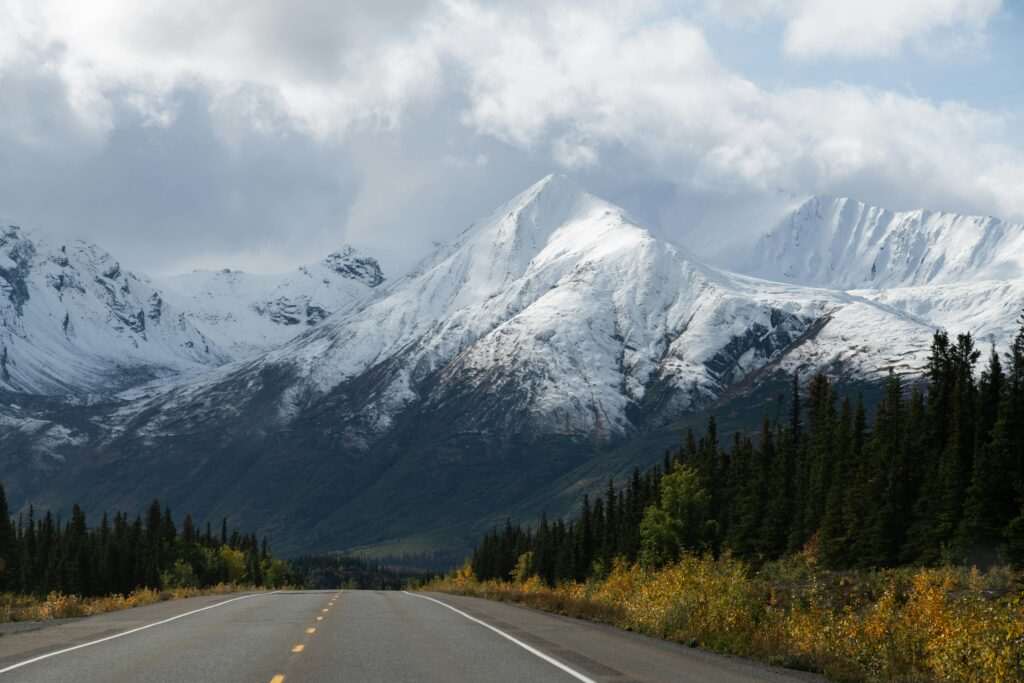
Beyond Palmer, the highway narrows and the scenery escalates rapidly. At mile 101, Matanuska Glacier comes into view from the road — one of the largest road-accessible glaciers in Alaska, a 27-mile-long river of ice descending from the Chugach Mountains. Matanuska Glacier State Recreation Site provides an overlook, and several private access points allow visitors to walk onto the glacier with a guide. The ice surface, crevasses, and moulins are impressive up close. Most guided glacier walks take 2 to 4 hours on the ice. Arrive before noon in summer to avoid afternoon cloud buildup that frequently obscures the upper glacier.
Hatcher Pass Road: Palmer to Willow
The Hatcher Pass Road loops between Palmer on the south side and Willow on the Parks Highway to the north, crossing a high alpine pass that sits in a completely different ecological zone from the valley below. The southern approach climbs steeply from Palmer through spruce forest into open subalpine meadows, then above treeline into tundra at the 3,886-foot summit.
Hatcher Pass and Independence Mine State Historical Park is the centerpiece of the drive. The 271-acre mine site preserves the remains of a 1930s gold mining operation above treeline — bunkhouses, mine shafts, and ore processing facilities scattered across a dramatic alpine landscape. Interpretive trails wind through the site. In July and August, the surrounding meadows are carpeted with wildflowers: fireweed, lupine, and arnica covering the hillsides above the mine buildings.
The road over the pass is paved on the southern approach but turns to gravel for the northern descent toward Willow. The northern section requires a high-clearance vehicle in wet or icy conditions. In winter, Hatcher Pass is a popular snowmobile and cross-country skiing area; the road may be gated at the summit in deep snow. Check current road conditions before driving the northern section.
Allow half a day for a Hatcher Pass loop from Anchorage: 45 minutes to Palmer, an hour up to Independence Mine, time at the mine site, and a return the same way or a loop via the Parks Highway if the northern section is passable.
Parks Highway: Anchorage toward Denali
The Parks Highway runs north from Wasilla (45 miles from Anchorage) toward Denali National Park, 240 miles from Anchorage. The section between Wasilla and Talkeetna covers agricultural flatland and boreal forest — pleasant enough but not especially scenic until the Alaska Range begins to appear on the northwestern horizon near mile 130.
Talkeetna, at the end of a 14-mile spur road at mile 99, is the most worthwhile stop on a Parks Highway drive. The small town is the base camp hub for Denali mountaineering expeditions and the departure point for Denali flightseeing tours. The historic downtown, a one-block strip of log buildings from the early 20th century, has excellent restaurants and a genuine small-Alaska-town character. The view of Denali on a clear day from Talkeetna is one of the most photographed in the state.
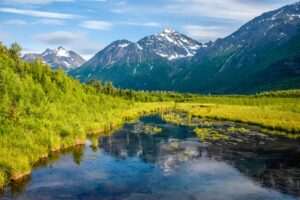
Continuing north on the Parks Highway, the Alaska Range grows steadily closer. Broad Pass, at 2,400 feet elevation near mile 195, is the highest point on the highway and offers open tundra views in all directions. On a clear day, the Alaska Range stretches across the entire western horizon. Moose are common through the spruce bogs on either side of the highway in this section.
Wildlife on Alaska Highways
Alaska highway driving means regular wildlife encounters, and a few practical guidelines prevent dangerous situations. Moose are the primary hazard — large enough (up to 1,500 lbs) to total a vehicle and unpredictable enough to cross the road without warning. Dawn and dusk are peak movement times. If a moose is on the road, stop and wait; do not honk or try to drive around it through vegetation at the road’s edge. Moose collisions cause serious injuries every year.
Bears are occasionally seen from the road in the Portage Valley, Glenn Highway above Sutton, and Parks Highway through boreal sections. Do not stop on the road shoulder to photograph bears — pull fully into a designated pullout, stay in the vehicle unless the area is clearly safe, and do not approach. Eagles, caribou, and Dall sheep are visible from moving vehicles and can be observed from pullouts with binoculars without stopping on travel lanes.
Alaska Driving Practicalities
Fuel up in Anchorage before any of these drives. Gas stations are present in communities along each route (Girdwood on the Seward Highway, Seward at the end, Palmer and Glennallen on the Glenn, Talkeetna on the Parks, Wasilla at the Parks junction), but stations in small communities sometimes have limited hours or run out in peak season. Carry a full tank out of Anchorage.
Road surfaces on all main highways are paved, though frost heaves create rough sections that appear seasonally. Hatcher Pass north side is gravel. Cell coverage is reliable through Turnagain Arm and the Matanuska Valley but drops significantly past Palmer on the Glenn, and past Talkeetna on the Parks. Download offline maps before departing.
Speed limits are 65 mph on most two-lane sections, but conditions frequently require slower speeds — blind curves, wildlife crossings, RV traffic, and gravel in road construction zones. Alaska has strict DUI enforcement; the alcohol culture at small roadhouse stops can be misleading about what counts as impaired in a jurisdiction that polices rural highways seriously.
Best Driving Season
Late May through September covers all four routes in their best condition. June and July deliver the longest days (up to 19.5 hours of daylight at summer solstice), which means driving at any hour is essentially a daylight experience. August brings early hints of fall color starting in higher elevations. September offers the full fall display — birch trees turning gold throughout the Matanuska Valley and Chugach foothills — and significantly less traffic than peak summer.
October through April is possible on the Seward and Glenn Highways, which are maintained year-round, but winter driving requires studded tires (available as rentals in Anchorage from October 1 through April 15) and awareness of black ice, avalanche closures, and limited services. Hatcher Pass over the summit is not reliably driveable in winter without a snowmobile or skis.
Self-Drive vs. Guided Tours
A rental car provides maximum flexibility — stop when you want, linger at a pullout without a schedule, and combine drives that no single guided tour covers in one day. The trade-off is local knowledge: a good guide knows exactly which cliffs to watch for Dall sheep at mile 112, where the bore tide is most visible from Bird Point on a given day, and which Matanuska Glacier access point currently has the best surface conditions.
For visitors who want a curated experience without the driving overhead, guided day trips run to Matanuska Glacier and Hatcher Pass from Anchorage daily through the summer. These typically include transportation, narration, and organized time at key stops — efficient for a single destination but less flexible for combining multiple corridors.
Recommended Itineraries
1-Day Loop: Anchorage → Seward Highway south → Alaska Wildlife Conservation Center → Portage Glacier → return via Seward Highway. Eight to nine hours including stops. This covers Turnagain Arm completely and includes the two best roadside stops on the corridor.
2-Day Loop: Day 1: Anchorage → Glenn Highway → Eagle River Nature Center → Palmer → Matanuska Glacier → overnight in Palmer or Wasilla. Day 2: Palmer → Hatcher Pass → Independence Mine → return to Anchorage via Palmer. Covers the Glenn Highway and Hatcher Pass thoroughly in two days.
3-Day Loop: Day 1: Seward Highway south, overnight in Seward. Day 2: Return via Seward Highway with Portage Glacier detour, continue north on Parks Highway to Talkeetna, overnight. Day 3: Talkeetna area exploration or Hatcher Pass via the Willow approach, return to Anchorage. Covers three of four major corridors and includes an overnight at each end for proper exploration time. Prince William Sound Glacier Tours operate from Whittier, accessible as a short add-on from the Seward Highway, making the three-day itinerary even more complete for visitors whose primary interest is glacial environments.
No comments yet.