Skagway Alaska 2026: Gold Rush History, White Pass Railway & the Road to the Yukon
In the summer of 1897, word reached Seattle that prospectors had struck gold in the Klondike, deep in Canada’s Yukon Territory. Within months, a hundred thousand people were making their way north. The fastest route went through a narrow, muddy inlet in Southeast Alaska that the Tlingit people called Skagua — the place where the north wind blows. Stampeders renamed it Skagway, built a boomtown overnight, and then poured over the mountains into Canada by the tens of thousands, carrying everything they owned on their backs.
Most didn’t find gold. The town they left behind, however, is still there — and in 2026 it remains one of the most atmospheric and historically intact small towns in Alaska. If you’re drawn to places where history didn’t get cleaned up, Skagway is worth making the journey.
Getting to Skagway from Anchorage
Skagway sits in Southeast Alaska, separated from the road system that connects Anchorage to most of the state. Getting there requires a deliberate choice of route — and both options are worthwhile in their own right.
- By air: Alaska Airlines operates flights from Anchorage to Skagway via Juneau, with total travel time around two hours. It’s the fastest option and opens up same-day arrival. The approach into Skagway — descending between sheer mountain walls with the Lynn Canal visible below — is a preview of the scenery to come.
- By Alaska Marine Highway ferry: The ferry system connects Southeast Alaska’s communities in a way no road can. From Bellingham, Washington (or from Juneau or Haines), the ferry winds through the Inside Passage to Skagway. It’s a slower journey measured in days rather than hours, but the passage through fjords, islands, and channels is its own destination. For travelers with time, the ferry is the right call.
From the north, Skagway is also accessible by road from Whitehorse in Canada’s Yukon Territory — about 180 km (110 miles) via the Klondike Highway. This makes Skagway a natural gateway or endpoint for Yukon road trips.
Klondike Gold Rush National Historical Park
The National Park Service manages much of downtown Skagway as a living historical district — which is to say the buildings haven’t been rebuilt as a simulation; they’re the actual originals. Walking the Broadway district in 2026, you’re looking at structures that stampeders looked at in 1898. The false-front storefronts, the boardwalks, the narrow lots — it’s the genuine article.
Ranger-led tours depart from the visitor center multiple times daily during summer and cover the history of the Gold Rush era, the con men and legitimate merchants who populated the boomtown (Soapy Smith, Skagway’s infamous gangster, looms large in the interpretation), and the extraordinary logistical challenge of the stampede itself. The park is free to enter; ranger programs are free. Allow at least half a day here.
The park also includes the Dyea unit, the Chilkoot Trail corridor, and interpretive sites throughout the region — it’s larger than its downtown footprint suggests.
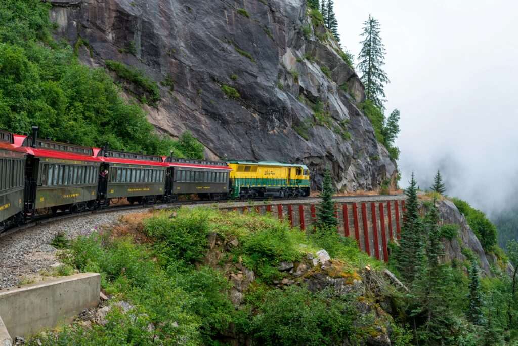
White Pass & Yukon Route Railway
If you do one thing in Skagway, make it the White Pass & Yukon Route railway. The WP&YR is a narrow-gauge historic railway that opened in 1900, just as the Gold Rush was winding down, built specifically to carry supplies and passengers over White Pass into the Yukon. The engineering was considered nearly impossible — and the results still look it.
In 20 miles, the train climbs 2,885 feet, crossing trestle bridges over gorges, threading tunnels blasted through granite, and clinging to cliff faces above valleys that fall away hundreds of feet below the tracks. On clear days, the views of the Lynn Canal, the Skagway River valley, and the surrounding Coast Mountains are staggering. The railway is listed as an International Historic Civil Engineering Landmark, alongside the Panama Canal and the Eiffel Tower.
The summit excursion — the standard tourist option — runs from Skagway to the White Pass summit at the US-Canada border and back, taking approximately three hours. Extended trips into British Columbia and Yukon are available for those continuing north. Book well in advance; the trains fill up, especially on cruise ship days when Skagway’s population temporarily doubles or triples.
The Chilkoot Trail
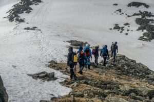
For serious hikers, the Chilkoot Trail is one of the most historically charged backcountry routes in North America. This is the path the stampeders walked — or more accurately, climbed, crawled, and dragged their gear over — during the winters of 1897-98. The Canadian government required each person to bring a year’s worth of supplies (roughly a ton of goods) before crossing the border, which meant most stampeders made the climb thirty to forty times, ferrying their loads in relays.
The trail covers 33 miles (53 km) from Dyea, near Skagway, to Bennett, British Columbia, crossing the 3,525-foot Chilkoot Pass at the summit. It takes most hikers three to five days. The landscape changes dramatically from coastal forest to alpine tundra to boreal meadow as you cross the pass.
Permits are required and limited — Parks Canada manages the Canadian portion, US National Park Service manages the American side, and the permit system coordinates between them. Book through Parks Canada reservations well in advance if a summer trip is your goal; permits sell out months ahead. At Bennett, a White Pass & Yukon Route train provides the return to Skagway, which is a satisfying and historically resonant way to close the loop.
Dyea Ghost Town & the Skagway River
Nine miles from Skagway, connected by a winding gravel road, Dyea was the competing boomtown at the start of the Chilkoot Trail. In 1897-98, Dyea had a population of 8,000 and was Skagway’s rival for dominance of the stampede traffic. When the White Pass railway made the Skagway route faster, Dyea collapsed almost overnight. By 1903, it was effectively abandoned.
Today Dyea is a flat, forested area with the foundations of buildings gradually disappearing into the landscape. Interpretive signs identify former streets. Cottonwood trees have grown up through what were once busy commercial lots. It’s a genuinely eerie and moving place — a boomtown that didn’t survive its own moment. The Skagway River runs along the edge of the townsite, and the area is productive for birdwatching in spring and summer.
Day Hikes Near Skagway
Denver Glacier Trail: A 4-mile round-trip hike following an old railway grade up the Denver Creek valley to a viewpoint above the Denver Glacier. Moderate difficulty, significant elevation gain in the upper section, outstanding views of the glacier and surrounding peaks. The trailhead is accessible by the White Pass railway — arrange drop-off and pick-up with the railway if you don’t want to road-walk.
AB Mountain (Skyline Trail): A demanding 6-mile round-trip with 3,500 feet of elevation gain up the prominent mountain that dominates the view above Skagway. The summit offers a panoramic view of the Lynn Canal, the Skagway River valley, and the White Pass corridor. Fit hikers only; bring layers regardless of the weather in town, as conditions at the summit are significantly more severe.
Continuing into the Yukon: Whitehorse Connection
Skagway is where the Klondike Highway begins its run north into Canada. Whitehorse, Yukon’s capital, is 180 km away — a two-to-three hour drive through the dramatic mountain landscapes of the White Pass and the Yukon interior. From Whitehorse, the Klondike Highway continues another 530 km to Dawson City, the epicenter of the Gold Rush, where the original Klondike strike was made.
For travelers building a broader Alaska-Yukon itinerary, Skagway makes a natural pivot point: fly in, spend two to three days, ride the railway, and drive north into the Yukon for an entirely different chapter of the journey.
Cruise Ship Timing: Go Early
Skagway is one of the busiest cruise ports in Alaska — on peak days, multiple ships dock simultaneously, and the town’s year-round population of roughly 1,000 people is outnumbered ten to one by visitors. Broadway fills quickly. The White Pass trains book out. Restaurants have lines.
The solution is simple: be on Broadway by 8 a.m. Ships dock mid-morning and passengers disperse through town by 10 or 11. The early hours before the crowds arrive are when the historic district feels closest to what it once was — quiet, weathered, and genuinely old. The ships leave by late afternoon, and the town returns to itself again.
Independent travelers staying overnight gain the best of both worlds: the daytime energy, and the rare quiet of Skagway after the last ship departs.
No comments yet.