Turnagain Arm Guide 2026: Bore Tides, Beluga Whales & Scenic Stops
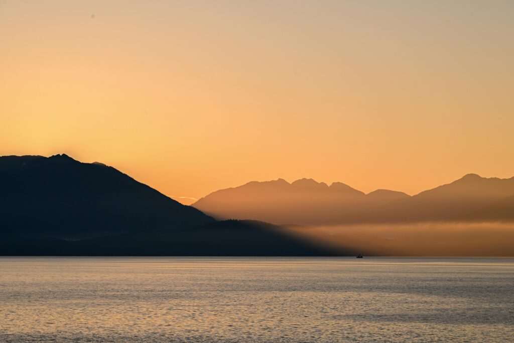
Turnagain Arm is the 48-mile inlet that runs southwest from Anchorage between the Chugach Mountains and the Kenai Mountains, and the Seward Highway that traces its northern shore is one of the most spectacular drives in North America. Most visitors experience the Arm as scenery glimpsed between Anchorage and somewhere else — Seward, Girdwood, Homer. The Arm rewards more deliberate attention. It has a tidal system that produces a daily bore tide wave, a beluga whale population that uses the inlet as a summer feeding corridor, Dall sheep that come down to the highway-level cliffs at Windy Corner, and a historical layer connecting back to the Iditarod Trail that predates the highway entirely. Here is what you are actually looking at, and where to stop to see it properly.
The Bore Tide
Turnagain Arm has one of the highest tidal differentials in the world — up to 38 feet between low and high tide. That extreme range, combined with the narrowing funnel shape of the inlet as it runs southwest, produces a phenomenon called a bore tide: a wave 2–6 feet high that rolls up the Arm from the inlet mouth, visible from the highway as a moving white line crossing the mudflats at speeds of 10–15 mph.
Bore tides occur roughly twice a day and are most dramatic in the 2–3 days following a new or full moon, when tidal differentials are largest. The timing is predictable — the bore arrives at the Bird Point viewpoint (mile 96.5 of the Seward Highway) approximately 2 hours and 15 minutes after low tide at Anchorage. The Alaska Bore Tide website and the NOAA tide prediction tool for Anchorage are the standard timing resources; search “Anchorage tide predictions” and subtract 2:15 for Bird Point arrival time. The bore is most impressive at the highest tidal differentials of the year; a calm, clear morning with good light makes it photogenic. It is not always a dramatic wall of water — on smaller tidal days it reads more as a line of chop moving against the current — but the mechanics of watching a tide arrive as a wave rather than a gradual flood are genuinely strange and worth the stop.
Best viewing pullouts: Bird Point (mile 96.5) has a large parking area and elevated viewpoints directly above the mudflats. Beluga Point (mile 110) also offers good bore tide viewing and combines it with beluga whale habitat. Allow 30–45 minutes at the pullout; the bore takes time to travel the width of the viewable section.
Beluga Whales
The Cook Inlet beluga whale population is genetically distinct from all other beluga populations and classified as critically endangered, with roughly 280 animals remaining. They use Turnagain Arm as a summer feeding corridor, following the tidal currents to chase salmon and smelt through the shallows. From late May through August, belugas are visible from the highway — white shapes moving along the mudflat edges — with sightings concentrated around Beluga Point (mile 110) and the Bird Creek area.
The Cook Inlet Beluga Whale Viewing corridor along the Seward Highway is one of the few places in the world where critically endangered whales are visible from a public road. NOAA guidelines ask that viewers not approach within 100 feet of belugas in the water and that boats maintain 300-foot distance; from the highway pullouts, viewing is passive and legal. Binoculars improve the experience significantly — the whales blend against the grey-brown mudflats at distance. Best viewing window: incoming tide, when belugas move into the shallows to herd fish against the banks.
Dall Sheep at Windy Corner
At mile 106.9, the Seward Highway passes directly below a cliff band called Windy Corner, where Dall sheep come down to lick minerals from the rock face at close range to the road. This is not a guaranteed sighting — sheep move unpredictably — but it is among the most accessible large-mammal wildlife encounters in Alaska. From late spring through summer, ewes with lambs are regularly visible at the base of the cliffs, close enough that binoculars are optional. The parking area is small and fills quickly on summer weekends; arrive early morning or late afternoon for lower traffic and better light. Do not approach or feed the sheep — the mineral lick is a natural behavior and human habituation disrupts it.
The Iditarod National Historic Trail
Before the Seward Highway existed, Turnagain Arm was a winter travel corridor: a dog sled and foot route connecting Seward to Anchorage that formed part of the trail system that would eventually be formalized as the Iditarod. Sections of the historic trail still run along the north shore of the Arm, paralleling the modern highway. The trail was used to carry mail, supplies, and gold through the early 20th century, and the bore tide — then as now — was one of the hazards of winter travel on the Arm’s frozen surface, which was unpredictably cracked by tidal action beneath the ice. The modern Iditarod Trail Sled Dog Race follows a northern route from Anchorage to Nome, but the Seward-to-Anchorage section of the historic trail is preserved and accessible to hikers at several points along the highway.
Girdwood Junction and Crow Creek Mine
At mile 90, the highway passes the junction for Girdwood — a left turn leading to Alyeska Resort and the Girdwood village 2 miles off the highway. The Crow Creek Mine road branches off the Girdwood approach, leading 3 miles up a gravel road to a working gold mine from the 1896 gold rush era. Crow Creek Gold Mine preserves original mining structures and allows visitors to pan for gold in the creek, which historically produced significant placer gold. Open daily mid-May through September; entry and panning fee is modest. The drive to Crow Creek is one of the more distinctive half-hour diversions available on the Turnagain Arm run.
Potter Marsh at the North End
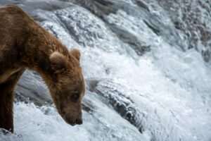
At the northern end of Turnagain Arm, where the highway re-enters the Anchorage municipal area at mile 117, Potter Marsh Bird Sanctuary is a 565-acre wetland managed by the Alaska Department of Fish and Game. A boardwalk extends over the marsh, providing elevated viewing of the nesting area without disturbing birds. The marsh hosts more than 130 species, including Arctic terns, trumpeter swans, red-necked grebes, and multiple dabbling duck species. Sockeye salmon run through the drainage in late summer, and brown bears have been documented foraging in the marsh during salmon season. Potter Marsh is the natural bookend to a southbound Turnagain Arm drive — worth a 30-minute stop before re-entering Anchorage — and is free to access year-round.
Practical Guide to Driving the Arm
The pullouts along the Seward Highway require care in summer: the road is narrow, pullout entrances come up quickly at highway speed, and traffic on summer weekends is significant. Key stops from north to south:
- Potter Marsh (mile 117): Boardwalk, birdwatching, free parking.
- McHugh Creek (mile 112): Trailhead parking; views up the cliff band toward Suicide Peaks.
- Beluga Point (mile 110): Primary beluga viewing pullout; bore tide viewing; interpretive signs.
- Windy Corner (mile 106.9): Dall sheep cliff; small pullout — arrive early.
- Bird Point (mile 96.5): Best bore tide viewing platform; large parking area.
- Bird Creek (mile 101): Campground, salmon fishing in season, access to Bird Ridge trailhead.
- Girdwood Junction (mile 90): Turn for Alyeska, Crow Creek Mine, Girdwood village.
Allow 3–4 hours to drive the Arm with stops; longer if you are timing a bore tide or spending time at Girdwood. The highway continues south to Seward (another 2 hours) or to Homer via the Sterling Highway junction (another 3 hours). Turnagain Arm is rarely the destination in itself — it is the corridor that makes every other Southcentral Alaska trip better when you slow down to pay attention to it.
Featured photo by John De Leon on Pexels.


No comments yet.