Kobuk Valley National Park 2026: Arctic Sand Dunes & Caribou in Alaska’s Hidden Gem
Kobuk Valley National Park contains something that should not exist: 25 square miles of active sand dunes, some reaching 650 feet high, above the Arctic Circle in Alaska. The Great Kobuk Sand Dunes are not a geological oddity footnoted in a visitor center — they are a genuine desert landscape surrounded by boreal forest and Arctic tundra, formed over millennia by glacial outwash and wind, maintained by the same forces today. In summer, temperatures on the dune surface can exceed 100°F. There are caribou tracks in the sand. There are no roads into the park. There are no visitor facilities of any kind. Getting there requires a flight to Kotzebue followed by a bush plane into the valley, and the experience rewards every logistical complication with a landscape that has no equivalent in the national park system.
Getting There: The Access Problem
Kobuk Valley is one of the least-visited national parks in the United States — not because it lacks remarkable features, but because reaching it is genuinely difficult. The park has no roads, no maintained trails, no lodges, and no established campgrounds. Access requires flying.
The standard approach from Anchorage begins with a commercial flight to Kotzebue (also spelled Quyuk in Iñupiaq), a coastal community of approximately 3,300 people above the Arctic Circle on the Chukchi Sea coast — about 550 miles northwest of Anchorage, with Alaska Airlines service from Ted Stevens Anchorage International Airport. From Kotzebue, charter bush planes operated by local air services fly into the Kobuk Valley, landing on gravel bars along the Kobuk River or near the dunes. The flight from Kotzebue takes approximately 30 to 45 minutes; charter costs vary by operator and aircraft but typically run $300–$500 per person round-trip.
The towns of Kobuk and Ambler, Iñupiaq villages along the river within or near the park, also serve as jumping-off points for river-based access. Paddlers float in from Ambler downriver through the park, or fly into a put-in point and paddle to a takeout where another charter picks them up. The National Park Service maintains a visitor contact station in Kotzebue — visit before flying into the valley for current conditions, bear activity, and river levels.
The Great Kobuk Sand Dunes
The dunes cover approximately 25 square miles on the south side of the Kobuk River valley, bounded by forested slopes and open tundra. The Great Kobuk Sand Dunes are the largest active sand dunes in the Arctic, and standing among them requires genuine recalibration of expectations. The sand is tan and fine, the ridgelines are sharp in morning light and soft in afternoon haze, and the treeline beyond the dunes’ edges makes the landscape look like a splice of two different biomes — which is exactly what it is.
The dunes formed from glacial silt deposited during the last ice age, reworked by wind for thousands of years into the forms visible today. They remain active — wind-driven changes in the ridgeline profile are measurable season to season. Walking on them is uncomplicated physically but disorienting spatially; the scale takes time to process. The Little Kobuk Sand Dunes and Hunt River Dunes are smaller formations within the park that receive even fewer visitors and are accessible on foot or by packraft from river access points.
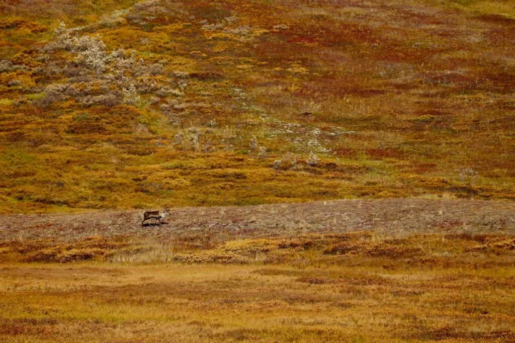
The Western Arctic Caribou Herd
The Western Arctic caribou herd is one of the largest land mammal migrations on earth — a population of several hundred thousand animals that moves seasonally across northwestern Alaska in routes that have persisted for thousands of years. The herd’s fall migration brings animals through and across the Kobuk Valley, crossing the river in groups that can number in the thousands at a single crossing point. The timing varies by year but typically runs from late August through October; September is the peak window for seeing the migration in the valley.
Watching a caribou river crossing is one of Alaska’s most extraordinary wildlife experiences, and Kobuk Valley is one of the best places in the state to witness it on foot — or from a packraft, floating quietly beside a gravel bar as animals move through. The herds also use the dunes as mineral licks; caribou tracks are a constant presence on the dune surface from late summer onward. The archaeological record at Onion Portage confirms that humans have hunted caribou at this same crossing point for over 12,000 years.
Onion Portage: One of North America’s Most Important Archaeological Sites
On a bend in the Kobuk River within the park, Onion Portage is a site where caribou have crossed the river since the last ice age — and where humans have hunted them for at least 12,500 years, making it one of the oldest and most continuously occupied archaeological sites in North America. Excavations in the 1960s revealed 16 distinct cultural layers, spanning from the earliest Arctic small tool tradition through Iñupiaq cultures to the present. The site is currently protected within the national park; there are no visitor facilities, but floating past it on the Kobuk River with awareness of what lies beneath the bank is its own kind of education.
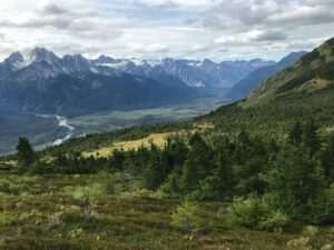
The Kobuk River as a Paddling Route
The Kobuk River is the primary travel corridor through the park, and a packraft or canoe journey through the valley is the most immersive way to experience it. The river is Class I-II — no technical whitewater — with a gentle current moving through braided gravel-bar channels and forested banks. A typical float through the park covers 60 to 80 miles over 5 to 10 days, depending on put-in and takeout points. Paddlers fly in to an upper put-in near Ambler, float through the park past the dune access points and Onion Portage, and arrange pickup or continue floating to Kotzebue.
Wildlife encounters from the river are consistent and close: Dall sheep on the valley walls, moose in the riparian willows, and — in migration season — caribou crossing directly in front of your boat. The dunes are accessible by foot from gravel bar landings on the river’s south bank. This is the mode of travel for which the park was designed, or more accurately, for which humans have used this valley for thousands of years.
Expedition Preparation
Kobuk Valley has no services, no rescue infrastructure, and no cell coverage. Planning must be complete before you leave Kotzebue. Every calorie of food must be carried in; every piece of gear must account for the full range of Arctic weather, which can include hard frost and heavy rain in August. Essential equipment: bear canister or electric fence for food storage (brown bears are present throughout the valley), satellite communicator (Garmin inReach or equivalent — not optional), packraft or canoe if floating, waterproof tent rated for wind, layers appropriate for 40°F to 100°F temperature swings on the dunes, water filter, first aid kit, and a thorough float plan filed with the NPS and someone at home.
File a trip plan with the National Park Service contact station in Kotzebue before entering the park. Confirm your charter flight return logistics before you fly in — being stranded by weather in Kobuk Valley is a real scenario that requires emergency reserves of food and fuel.
Why Kobuk Rewards the Effort
Most national parks can be experienced in a day from a road. Kobuk cannot. The logistical investment required — the flights, the planning, the weight of a fully self-supported kit — filters out the casual visitor almost entirely. The result is a park that feels genuinely unpeopled, where the landscape operates on its own terms without reference to human convenience. The dunes are not a backdrop; they are the thing itself, ancient and current simultaneously, crossed by caribou that don’t know they are in a national park.
Kobuk Valley is the park you fly to when the road parks are no longer enough. The sand dunes above the Arctic Circle exist whether or not anyone is there to see them — they have been there for ten thousand years and will be there long after the last bush plane turns for home. Getting there is the point. The landscape is the reward.
Featured photo by John Fairchild on Pexels.


No comments yet.