Denali Highway Road Trip 2026: Alaska’s Most Remote & Scenic Drive
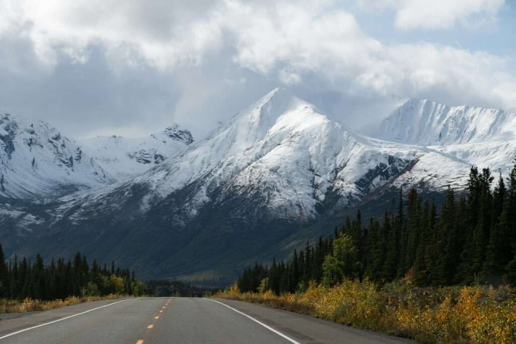
The Denali Highway is 135 miles of gravel road connecting Cantwell on the Parks Highway to Paxson on the Richardson Highway, crossing the Alaska Range foothills at elevations that put the full sweep of the range on the horizon. There are no towns on the road, almost no traffic, and in clear weather, Denali itself is visible from the western sections — the highest peak in North America rising above a tundra plateau with nothing between you and it. This is not a road trip with scheduled stops and restaurant recommendations. It is a wilderness drive that requires a prepared vehicle, extra fuel, and the willingness to move at whatever pace the landscape demands. For visitors based in Anchorage, it forms the backbone of the best Alaska interior loop you can drive.
Road Basics
The Denali Highway is unpaved for most of its length — paved sections exist near each end, but the majority is gravel. The road is maintained by the Alaska Department of Transportation and is generally passable in a high-clearance vehicle; low-clearance sedans and small cars risk undercarriage damage, punctured tires, and getting stuck in the washboard sections that develop mid-season. Four-wheel drive is not always required but is significantly reassuring on the rougher stretches.
Bring at least two spare tires. Gravel roads eat tires, and the distance between you and the nearest tire shop (Cantwell or Paxson, at either end) is too great to manage with one spare. Cell service is essentially nonexistent for the entire route. There are no gas stations between the endpoints; fill up before you enter and carry extra fuel if your vehicle’s range is under 200 miles. Check Alaska DOT road conditions at 511.alaska.gov before departure — conditions can shift significantly after rain or in early and late season.
The road is typically open from late May through early October. Snow can close it at either end of the season, sometimes without much warning. The peak driving window is mid-June through mid-September, when the tundra is at its most vivid and wildlife activity is highest.
One important note for visitors: most rental car agreements prohibit driving on unpaved roads. If you are renting, read the fine print carefully — driving the Denali Highway with a standard rental car may void your coverage. Some Alaska outfitters and specialty rental companies offer vehicles cleared for gravel road use.
The Drive: West to East, Cantwell to Paxson
Most Anchorage-based travelers enter from the west, joining the highway at Cantwell after driving north on the Parks Highway past Denali National Park. The first 30 miles from Cantwell are the most accessible — the paved section ends, and the road climbs into open tundra with the Alaska Range filling the northern horizon. On clear days, the profile of Denali becomes visible within the first hour of driving.
Brushkana Creek Campground (mile 104 from Paxson, approximately 31 miles from the Cantwell entrance) is a Bureau of Land Management campground set in spruce along a small creek — the first overnight option heading east, and a good base for exploring the western tundra. Campsites are first-come-first-served; no hookups, vault toilets. Free of charge.
Maclaren Summit, at 4,086 feet, is the highest point on the road and the defining viewpoint of the drive. The summit sits at roughly the midpoint of the highway and delivers a 360-degree panorama: the Alaska Range to the north, the broad Maclaren River valley below, tundra rolling in every direction. Even overcast days produce dramatic light here. Stop, walk out onto the tundra, and spend time with the view — this is what the Denali Highway is for.
The Maclaren River crossing sits below the summit. The river is classic Interior Alaska grayling water — clear, cold, and productive — and a short walk upstream from the bridge puts you in good fishing position. Arctic grayling are the primary target; they are voracious and acrobatic on light tackle and require only a standard Alaska fishing license to pursue.
The eastern third of the highway passes through the Tangle Lakes area, a complex of lakes and wetlands near Paxson that is one of the most archaeologically significant landscapes in Alaska. The Tangle Lakes Archaeological District contains evidence of human habitation spanning more than 10,000 years — some of the earliest documented presence of people in Alaska. BLM interpretive signs at the Tangle Lakes Campground (near mile 21 from Paxson) explain the significance; the campground itself is a good overnight for eastbound travelers. Fishing in the Tangle Lakes produces lake trout and arctic grayling; Upper Tangle Lake is particularly productive. A canoe or packraft extends access to the more remote lake sections.
Wildlife
The Denali Highway is one of the best wildlife corridors accessible by road in Alaska. The open tundra provides visibility that forested parks cannot match — you see animals at distance and can watch them for extended periods without disturbing them.
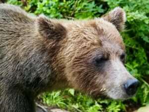
Caribou are the signature sighting. The Delta caribou herd ranges across the eastern Denali Highway corridor; herds of dozens to hundreds of animals are sometimes visible from the road in late summer and fall as they begin their seasonal movement. Grizzly bears are common — the tundra supports high densities, and a bear digging for ground squirrels on a hillside within binocular distance is a routine occurrence. Golden eagles patrol the ridgelines throughout summer; their thermals and hunting dives are visible from the road. Wolves are present and occasionally spotted crossing the road, particularly in early morning. Dall sheep occupy the higher terrain above the road; scanning rocky ridges with binoculars often finds them. Bring a quality pair — 8×42 minimum — and treat the drive as an extended wildlife observation rather than a point-to-point transit.
Lodging Along the Route
Overnight options on the Denali Highway are very limited and should be arranged in advance. The BLM campgrounds at Brushkana Creek and Tangle Lakes are free and require no reservation but have no services beyond pit toilets. Two private lodges operate on the road: Maclaren River Lodge, a remote fishing operation near the summit, and Gracious House Lodge in the middle sections of the highway. Both offer meals and lodging for highway travelers; call ahead before arrival, as capacity is small and availability varies by season. Do not assume you can show up without a reservation.
Adding the Denali Highway to Your Anchorage Road Trip
The highway’s positioning between the Parks Highway and the Richardson Highway makes it the natural connector for a loop out of Anchorage. The classic route:
- Day 1 — Anchorage to Cantwell via Parks Highway: Approximately 210 miles north (3.5–4 hours), with the option to stop at Denali National Park’s entrance area for the day. Overnight in Cantwell or the Denali area.
- Day 2 — Denali Highway, Cantwell to Paxson: The 135-mile crossing takes 3–5 hours with stops, more if wildlife is active. Overnight at Tangle Lakes Campground or Gracious House Lodge.
- Day 3 — Richardson and Glenn Highways back to Anchorage: South on the Richardson Highway to Glennallen, then west on the Glenn Highway — approximately 250 miles, 4–5 hours. Option to stop at Wrangell-St. Elias National Park’s Kennecott access road or the Glenn Highway’s Matanuska Glacier pullouts.
The full loop is approximately 600 miles. Three days is the minimum for a satisfying pace; four or five days allows genuine exploration of each section rather than transit driving.
Vehicle Preparation
Before entering the Denali Highway: verify tire condition (not just inflation — inspect tread and sidewalls), carry two spare tires and a floor jack, pack a basic tool kit and tire plug kit, fill the gas tank at Cantwell or Paxson, carry extra fuel if range is a concern, bring a paper map (Alaska Atlas or the BLM Denali Highway map), and download offline GPS maps before leaving cell range. A satellite communicator (Garmin inReach or similar) is a worthwhile investment for a drive this remote — it allows emergency messaging when cell service is unavailable.
The Denali Highway is not a road that rewards rushing. The tundra is enormous, the mountains are enormous, and the time between encounters — whether with a grizzly on a hillside or a clear view of Denali from the summit — is part of the experience. Drive it slowly, stop often, and bring enough food and water for an extra day in case you need it. The road has been there for decades. You can take your time.
Featured photo by John De Leon on Pexels.

No comments yet.