Anchorage Geocaching 2026
Anchorage’s trail network supports over 120 miles of urban trails, and thousands of geocaches are hidden along them — in the root systems of Sitka spruce, under trail-marker rocks in the Chugach foothills, inside magnetic hides on metal infrastructure along the coastal trail, and tucked into puzzle caches that require solving a riddle about Anchorage geography before you can find the coordinates. Geocaching turns Anchorage’s trail system into a scavenger hunt with a global ledger, making it particularly rewarding for visitors who want a structured reason to explore the city’s parks and green corridors beyond the standard highlights. This guide covers how to start geocaching, where the best cache concentrations are in and around Anchorage, what makes Anchorage a strong geocaching destination, and what to expect as a first-timer in 2026.
How Geocaching Works
Geocaching is an outdoor treasure-hunting activity where participants use GPS coordinates to find containers (“caches”) hidden by other players at locations worldwide. The Geocaching.com platform (and its companion app) maintains the database of active caches — you create a free account, browse caches near your location, navigate to the coordinates, find the physical container, sign the paper log inside, and log your find online. Premium membership ($30/year) unlocks additional cache types and filter options.
Caches range from nano-sized magnetic discs (barely visible, hiding a tightly rolled paper log) to large ammo cans with enough room for trinkets, notes, and small objects. The traditional cache exchange: if you take something from a cache, leave something of equal or greater value. Most urban caches in Anchorage are small to nano-sized due to the high muggle (non-geocaching public) traffic on popular trails.
Cache difficulty and terrain ratings run from 1–5 in each category. A D1/T1 cache is straightforward to find in accessible terrain. A D5/T5 cache might require solving a multi-step puzzle or reaching a location that involves technical climbing or backcountry travel. Most beginner geocachers do well starting with D1–2/T1–2 caches.
Tony Knowles Coastal Trail
The 11-mile Coastal Trail running from downtown Anchorage to Kincaid Park carries one of the highest cache densities of any trail in Southcentral Alaska. Hides cluster around distinctive natural features — overlooks onto Cook Inlet, bridge abutments, benches with Denali views — and the trail’s accessibility by foot from downtown hotels makes it the most convenient starting point for geocaching visitors. Expect a mix of nano magnetic hides on metal fixtures, small pill-bottle caches in rock piles, and the occasional creative hide that uses the Inlet views as a context clue.
Kincaid Park
Kincaid Park’s 3,500-acre forest of spruce and birch at the southern end of the Coastal Trail hosts an extensive cache network spread across 35+ miles of trail and ski track. The forest environment allows for more creative hides than the exposed coastal trail, and the park’s multiple trail levels (from flat paved paths to technical single-track) mean cache difficulty and terrain ratings span a full range. The biathlon range area and the south overlook (with views across Cook Inlet to the Alaska Range) are particularly productive cache zones.
The Far North Bicentennial Park trail system, five miles east of downtown on the Hillside, adds over 35 miles of multi-use trails with dozens of active caches distributed across the Campbell Creek Estuary and forest zones above.
Chugach State Park
Chugach State Park’s trail network east of Anchorage provides a different geocaching environment: more technical terrain, longer approaches, and caches that often reward hikers for reaching viewpoints or summits rather than rewarding urban trail exploration. The Flattop Mountain trail, one of the most-hiked routes in Alaska, has caches placed at multiple elevations including near the summit. The Glen Alps area, the Near Point trail, and the Rabbit Lake trail all have active caches at time of writing — check Geocaching.com for current active listings before heading out.
Palmer and Mat-Su Valley Caches
The Matanuska-Susitna Valley north of Anchorage (accessible via the Glenn Highway) offers a substantial cache network across different terrain than urban Anchorage. The Matanuska Glacier area, the Hatcher Pass corridors, and the Wasilla lake district all have active caches that integrate well with a day trip north. Hatcher Pass caches in particular reward summer hikers with alpine terrain hides that combine elevation gain with the puzzle of locating a container blending into a talus field.
Tips for Geocaching in Anchorage
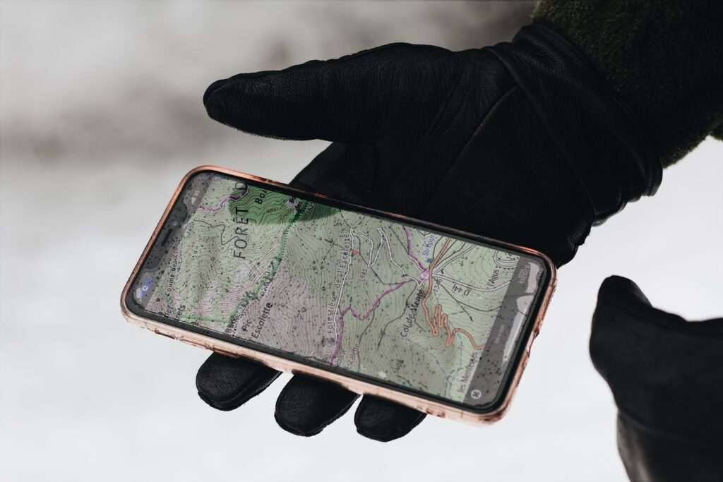
- Download offline maps: Cell service fades on Chugach trails within 1–2 miles of the trailhead. Download your cache waypoints and a section of the offline map before leaving the parking area.
- Watch for moose: Anchorage’s urban trail network crosses active moose habitat. Geocaching typically involves slow, attentive movement that can put you in close proximity to moose before you notice them. Maintain 50+ feet of distance and never approach calves.
- Log your finds promptly: Geocachers maintain the system by logging finds online; cache owners monitor their logs to confirm caches are still in place. A recent find log tells the next geocacher the cache hasn’t been muggled.
- Bring a pen: Every cache has a paper log. Digital apps handle online logging, but the physical signature in the container requires a writing implement. Many nano caches require a very small pen or pencil.
The Alaska Public Lands Information Center on 4th Avenue publishes trail maps for Chugach State Park access points and can advise on geocaching etiquette and current trail conditions on state and federal land.
Family Geocaching in Anchorage
Geocaching is one of the better family outdoor activities in Anchorage specifically because it provides a structured goal for children who might not otherwise stay engaged on a trail walk. Kid-friendly caches near parking areas and along the flat sections of the Coastal Trail or Chester Creek Trail let families with young children participate without demanding long hikes. The Geocaching.com “kid-friendly” attribute filter isolates caches identified by their placers as appropriate for families with children. Our free things to do in Anchorage guide covers the full range of zero-cost outdoor activities, and geocaching fits squarely in that category — the basic Geocaching.com account and app access are free. Our Anchorage hiking guide covers the trail network detail that makes geocaching in the Chugach foothills accessible to visitors unfamiliar with the area.
Photo by Arasya büyük on Pexels.

No comments yet.