McHugh Creek Trail 2026 — Scenic Day Hike in Chugach State Park
One of South Anchorage’s Best Views, Earned Step by Step
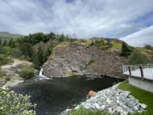
McHugh Creek Trail begins at a highway wayside and ends at an alpine lake ringed by peaks — with Turnagain Arm spread out below for most of the climb in between. The trail covers three miles one-way with roughly 2,400 feet of elevation gain, rated moderate to strenuous, and rewards hikers with views that rival anything accessible from the Anchorage road network. For visitors looking to push beyond a casual forest walk and earn a full mountain experience, McHugh Creek Trail delivers.
The Route to Rabbit Lake
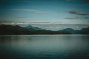
The trailhead sits at McHugh Creek Wayside on the Seward Highway at Mile 112, about 15 miles south of downtown Anchorage. A $5 daily parking fee applies — bring cash or a state park ParkPass. Restrooms are on-site. The trail begins in spruce and birch forest along the creek drainage, climbing steadily before breaking above treeline into open tundra. Once above treeline, views of Turnagain Arm open fully to the north and west and stay with you for most of the upper trail. The full route ends at Rabbit Lake, a glacially carved alpine lake at roughly 3,000 feet elevation, set against sharp ridgelines and lingering snowfields in early summer.
Table Rock: A Shorter Option
Hikers who want the view without committing to the full six-mile round trip have a natural turning point at Table Rock, a prominent rocky outcrop well above treeline. The Table Rock viewpoint offers the signature Turnagain Arm panorama without requiring the full climb to Rabbit Lake. For families with older children or hikers on a tighter schedule, turning around at Table Rock is a common and entirely satisfying choice.
The Turnagain Arm Trail Connection
At the trailhead, McHugh Creek Trail connects to the Turnagain Arm Trail, a separate multi-mile route that follows the Seward Highway corridor above the water. The connection allows hikers to combine both trails for a longer outing — the Arm Trail offers a flatter, scenery-rich option alongside the McHugh climb, and works as a standalone route from the same parking area for those who want arm views without the elevation gain.
Wildlife and Wildflowers
Dall sheep frequent the rocky ridges above the upper trail, often visible on the gray talus above Rabbit Lake. Marmots are common in the boulder fields — their sharp whistles typically announce your approach before you spot them. Bears inhabit the McHugh drainage and are active throughout summer; the Chugach Mountains Wildlife Viewing area to the north covers broader wildlife options in this corridor. Wildflowers peak in late June and July, with lupine, fireweed, and alpine forget-me-nots covering the open tundra slopes.
Bear Safety
Black bears and brown bears are present in the McHugh Creek drainage throughout the summer. Carry bear spray and keep it accessible — not buried in your pack. Make noise in areas with dense brush or reduced sightlines, particularly in the creek-side sections lower on the trail. Hike in groups when possible. Give any bear you encounter a wide berth and never approach or feed wildlife. Check with Alaska State Parks for current bear activity before heading out.
What to Bring
McHugh Creek is a strenuous hike that rewards proper preparation even as a day trip. Bring at least two liters of water per person — there’s no potable water on the trail, and creek water requires treatment. Hiking boots with ankle support are strongly preferred over trail runners given the steep gradient and rocky upper terrain. Bear spray should be clipped to your hip, not stowed in your pack. Layers are essential: the upper trail sits above 3,000 feet and weather changes quickly even on clear summer days. Trekking poles help considerably on both ascent and descent — the steep return down to the trailhead is where tired hikers lose their footing most often.
Getting There and Practical Notes
From downtown Anchorage, take the Seward Highway south approximately 15 miles to Mile 112 and turn into McHugh Creek Wayside on the right. The highway follows Turnagain Arm closely en route — watch for beluga whales in the inlet and Dall sheep on the cliffs above the road. The lot holds roughly 20 vehicles and fills quickly on summer weekends; arriving before 8 a.m. is the reliable strategy. Cell service is limited near the trailhead, so download offline maps beforehand.
Best Time to Visit
The upper trail is typically snow-free by late June. July brings peak wildflower conditions and the longest daylight for the full climb to Rabbit Lake. Late August through September delivers fall color on the tundra and excellent visibility for Turnagain Arm views. Winter snowshoeing reaches the lower sections, though the upper trail becomes technical terrain after the first significant snowfall.
Frequently Asked Questions
How difficult is McHugh Creek Trail near Anchorage?
McHugh Creek Trail is rated moderate to strenuous. The three-mile one-way route to Rabbit Lake gains approximately 2,400 feet of elevation. Solid footing and stamina are required, but no technical skills. Hikers wanting a shorter outing can turn around at the Table Rock viewpoint, which sits well below Rabbit Lake.
Is there a fee to hike McHugh Creek Trail?
A $5 daily parking fee applies at McHugh Creek Wayside. A state park ParkPass also covers the fee. No charge applies to trail access — only to parking at the wayside. Restrooms are available at the trailhead.
Are there bears on McHugh Creek Trail?
Yes. Black bears and brown bears are present in the McHugh Creek drainage throughout summer. Carry bear spray and keep it accessible. Make noise while hiking, travel in groups when possible, and never approach or feed wildlife. Check current bear activity reports with Alaska State Parks before your visit.
What’s the best viewpoint on McHugh Creek Trail?
The upper trail above treeline provides continuous Turnagain Arm views. Table Rock is a popular stopping point for panoramic views without the full climb. The Rabbit Lake basin offers the most dramatic alpine scenery — peaks, ridgelines, and the lake framing the end of the route.

No comments yet.