Driving the Seward Highway 2026: Alaska’s Most Scenic Road Trip
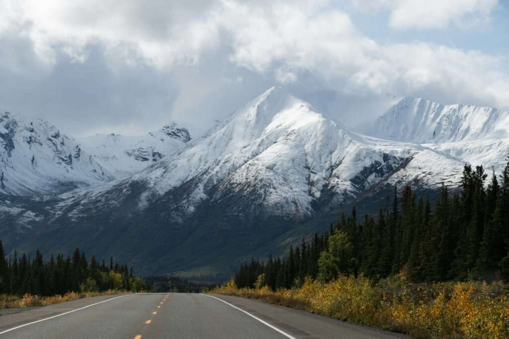
The Seward Highway runs 127 miles south from Anchorage to the coastal town of Seward, and it’s one of the most visually compelling drives in North America. The road earned All-American Road designation — one of only 31 in the country — for good reason: it skirts the edge of a narrow tidal arm with 40-foot bore tides, climbs through mountain passes, and deposits you in a national park with active glaciers. For most visitors, it’s the drive to Kenai Fjords. For anyone paying attention, it’s an experience in its own right.
Allow at least three hours each way to drive it with stops. Rushing it means missing most of what makes it worth doing.
Milepost 127–108: Leaving Anchorage, Entering Turnagain Arm
Heading south from downtown Anchorage, the highway passes through South Anchorage residential areas before the terrain opens dramatically around milepost 117 when Turnagain Arm appears on your right. The arm is a 48-mile finger of water squeezed between the Chugach Mountains on the north and the Kenai Mountains on the south — Cook Inlet narrows to a point here, and the tidal exchange is one of the most extreme in the world.
Your first major stop is Potter Marsh at approximately milepost 117, just south of the city. The Potter Marsh Bird Sanctuary boardwalk extends over a wetland system that draws trumpeter swans, Arctic terns, red-necked grebes, and dozens of other species during the spring and summer migration period. It’s a genuine birding destination that most drivers speed past without realizing what they’re missing. Budget 30–45 minutes if wildlife is a priority.
Milepost 108–95: Bore Tides, Belugas, and Dall Sheep
The stretch between McHugh Creek and Bird Creek is where Turnagain Arm shows off. Three things to watch for:
Bore tides: When the tide rushes back into the arm after a 40-foot drop, it creates a visible wave — the bore tide — that can be 6 feet high and travels at 10–15 mph. The best viewing points are the pullouts near Beluga Point (milepost 110) and Bird Creek. Bore tides are predictable — they happen roughly 2 hours after low tide at Anchorage, so check a tide table before you go if you want to time it. The experience of watching a wave roll through what looks like a sand flat is genuinely strange.
Beluga whales: The Cook Inlet beluga whale is a distinct, endangered subspecies, and Turnagain Arm is one of their feeding grounds. They’re most often spotted from Beluga Point and the area around Indian (milepost 104). They appear as small white shapes moving through the grey water, often in groups. There’s no guarantee, but multiple sightings per week are typical in summer. Pull over safely when you see other cars stopped — that’s usually the signal.
Dall sheep: The white sheep that live on the near-vertical cliffs above the highway are visible year-round with binoculars. The rocky outcrops between mileposts 107 and 105 are reliable spotting areas. Scan the grey cliff faces for white dots — when you find one, you’ll usually find a dozen.
The Turnagain Arm tide pools at lower tide levels are also worth exploring if your timing is right — the exposed mudflat at low tide reveals a surprisingly rich intertidal zone.
Milepost 101: Bird Creek
The Bird Creek Trail accesses one of the more accessible canyon hikes along the highway, climbing above the tree line into alpine terrain with views back down Turnagain Arm. In late summer, the creek itself is a productive salmon fishing location — the Bird Creek fishing area fills with pink and silver salmon anglers from July through September. Even if you’re not fishing, watching salmon in a clear creek is an experience worth stopping for.
Milepost 90: Girdwood and Alyeska Resort
The Alyeska Resort turnoff at milepost 90 is worth knowing even if you’re not skiing. The Girdwood valley has a distinctly different microclimate from the rest of the highway — warmer, wetter, and densely forested with enormous Sitka spruce. The resort’s tram runs year-round and provides aerial views of the valley and Prince William Sound on clear days. Girdwood’s small town center has several restaurants and the renowned Bake Shop for a mid-drive stop. Budget 45 minutes to an hour if you detour here — longer if you take the tram.
Milepost 78.9: Portage Glacier Spur
The turn at milepost 78.9 leads to a 5-mile spur road and one of the most visited spots in Alaska. Portage Glacier feeds directly into Portage Lake, and the Begich Boggs Visitor Center at the lake’s edge has excellent interpretive exhibits on glaciology, climate change, and the 1964 Good Friday Earthquake that reshaped much of this valley. The glacier has retreated significantly from the visitor center’s viewing area — on a clear day you can see it in the distance, but it’s no longer at the lake’s edge.
For a closer look, Portage Glacier Cruises (MV Ptarmigan) runs boat tours on the lake directly to the glacier face. This is one of the better value glacier experiences in Alaska — the combination of iceberg-studded water and a glacier that calves actively is compelling, and the boat ride is short enough to fit into a Seward Highway day without dominating it.
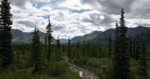
Milepost 78–36: Into the Interior
South of Portage, the highway climbs away from tidewater and into a more remote mountain corridor. The terrain shifts from coastal to interior: spruce forests, river valleys, and long views toward the Alaska Range on clear days. Traffic thins out noticeably once you’re past the Portage turnoff.
Summit Lake (milepost 45): A well-regarded pullout and rest area with a small lodge. The lake reflects the surrounding peaks on calm mornings — a frequently photographed location and a good place to stretch legs. The Summit Lake Lodge serves food and coffee.
Tern Lake Junction (milepost 37): The highway splits here — the Sterling Highway heads west toward Homer, while the Seward Highway continues south. Stay on the Seward Highway. The junction itself has a pullout with good Arctic tern viewing in early summer, when the birds nest in the area.
Milepost 36–0: Moose Pass to Seward
The last section of the drive follows the Resurrection River valley through classic Alaska boreal terrain — spruce, birch, and alder giving way to cottonwood as you descend. Moose Pass (milepost 29) is a small community of about 200 people, notable for its summer solstice festival and for being the point where many visitors start to realize the drive is almost over. Stop for the views of Upper Trail Lake if the light is good.
Seward appears suddenly as the valley opens onto Resurrection Bay — a deep, fjord-like inlet ringed by peaks. The town sits at the head of the bay, with the national park boat harbor a short drive from the main street. Your arrival gives you direct access to Kenai Fjords boat tours, Exit Glacier, and the Alaska SeaLife Center.
Best Time of Day to Drive
Southbound in the morning, northbound in the afternoon gives you the best light quality — morning sun illuminates the Chugach faces above Turnagain Arm from the east, while afternoon light catches the mountains on the return. Midday is the worst time photographically but fine otherwise. Driving south on a Friday afternoon means sharing the road with Anchorage weekend traffic; Tuesday–Thursday is noticeably quieter.
Seasonal Road Conditions
The Seward Highway is maintained year-round and passable in all seasons, but conditions vary significantly. Summer (May–September): straightforward on a paved, well-maintained road. Fall: watch for ice patches at elevation, particularly near the Summit Lake area. Winter: the highway stays open but requires ice-rated tires; avalanche closures at the mountain sections occur several times a year. Spring (April–May): variable — the lower stretches clear first, while upper sections can retain ice and snow into May. Always check the Alaska 511 road conditions app before departing in non-summer months.
Combining with Kenai Fjords
The standard approach: leave Anchorage by 7am, stop at Potter Marsh and Beluga Point, detour to Portage Glacier Cruises if time allows, arrive in Seward by 10am for a morning boat departure into Kenai Fjords National Park. Return drive in the late afternoon. The full circuit — Anchorage to Seward, boat tour, return — is genuinely doable as a single long day with early departure. Two days is more comfortable if you want time at Exit Glacier.
Featured photo by John De Leon on Pexels.

No comments yet.